You are here: Home > Network List > UU - University of Utah Regional Network Stations List
> Station BSUT Blindstream Canyon, Hanna, UT, USA > Earthquake Result Viewer
BSUT Blindstream Canyon, Hanna, UT, USA - Earthquake Result Viewer
| Earthquake location: |
Near Coast Of Venezuela |
| Earthquake latitude/longitude: |
10.9/-62.3 |
| Earthquake time(UTC): |
2013/10/12 (285) 02:10:27 GMT |
| Earthquake Depth: |
63 km |
| Earthquake Magnitude: |
6.0 MWW, 6.0 MWW, 6.0 MWB, 6.0 MWC, 6.0 MI |
| Earthquake Catalog/Contributor: |
NEIC PDE/NEIC COMCAT |
|
| Network: |
UU University of Utah Regional Network |
| Station: |
BSUT Blindstream Canyon, Hanna, UT, USA |
| Lat/Lon: |
40.54 N/110.76 W |
| Elevation: |
3211 m |
|
| Distance: |
51.8 deg |
| Az: |
313.48 deg |
| Baz: |
110.755 deg |
| Ray Param: |
0.066988595 |
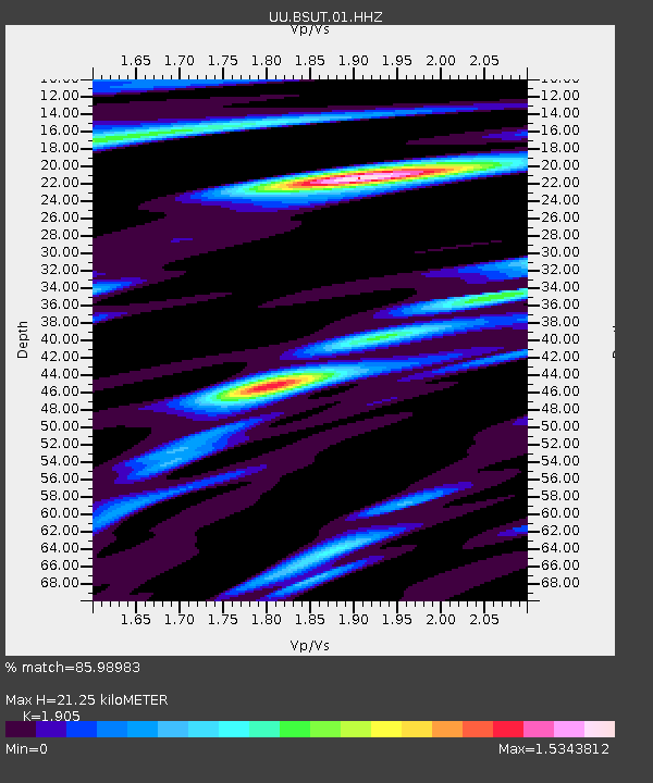
| Estimated Moho Depth: |
21.25 km |
| Estimated Crust Vp/Vs: |
1.90 |
| Assumed Crust Vp: |
6.155 km/s |
| Estimated Crust Vs: |
3.231 km/s |
| Estimated Crust Poisson's Ratio: |
0.31 |
|
| Radial Match: |
85.98983 % |
| Radial Bump: |
400 |
| Transverse Match: |
78.78895 % |
| Transverse Bump: |
400 |
| SOD ConfigId: |
626651 |
| Insert Time: |
2014-04-19 01:57:59.404 +0000 |
| GWidth: |
2.5 |
| Max Bumps: |
400 |
| Tol: |
0.001 |
|

Signal To Noise
| Channel | StoN | STA | LTA |
| UU:BSUT:01:HHZ:20131012T02:18:58.278007Z | 21.668402 | 5.6303666E-8 | 2.5984228E-9 |
| UU:BSUT:01:HHN:20131012T02:18:58.278007Z | 6.213905 | 1.4484733E-8 | 2.3310194E-9 |
| UU:BSUT:01:HHE:20131012T02:18:58.278007Z | 11.495172 | 2.4253588E-8 | 2.1098936E-9 |
| Arrivals |
| Ps | 3.3 SECOND |
| PpPs | 9.6 SECOND |
| PsPs/PpSs | 13 SECOND |


