You are here: Home > Network List > UU - University of Utah Regional Network Stations List
> Station TCRU Three Creek Reservoir, UT, USA > Earthquake Result Viewer
TCRU Three Creek Reservoir, UT, USA - Earthquake Result Viewer
| Earthquake location: |
Near Coast Of Venezuela |
| Earthquake latitude/longitude: |
10.9/-62.3 |
| Earthquake time(UTC): |
2013/10/12 (285) 02:10:27 GMT |
| Earthquake Depth: |
63 km |
| Earthquake Magnitude: |
6.0 MWW, 6.0 MWW, 6.0 MWB, 6.0 MWC, 6.0 MI |
| Earthquake Catalog/Contributor: |
NEIC PDE/NEIC COMCAT |
|
| Network: |
UU University of Utah Regional Network |
| Station: |
TCRU Three Creek Reservoir, UT, USA |
| Lat/Lon: |
38.61 N/112.45 W |
| Elevation: |
2293 m |
|
| Distance: |
52.4 deg |
| Az: |
310.632 deg |
| Baz: |
107.936 deg |
| Ray Param: |
0.066609815 |
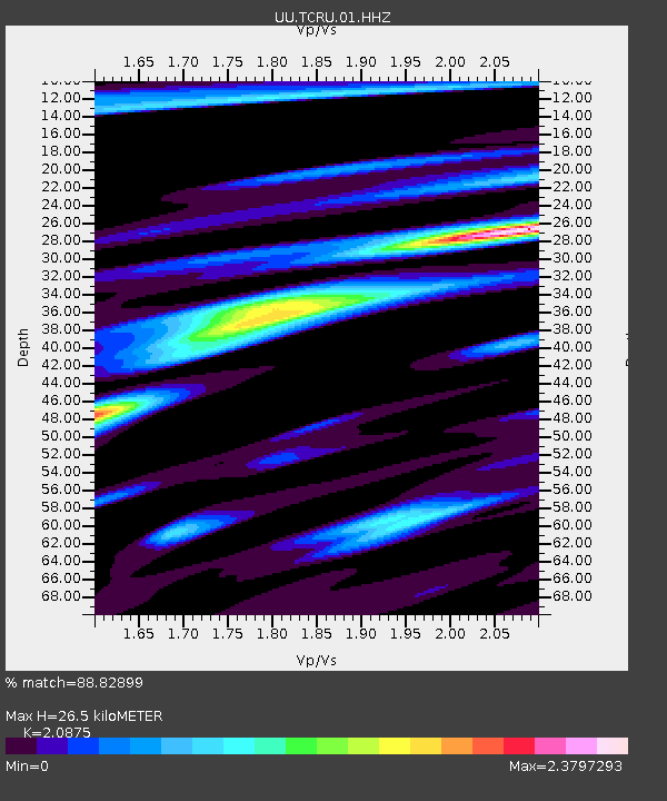
| Estimated Moho Depth: |
26.5 km |
| Estimated Crust Vp/Vs: |
2.09 |
| Assumed Crust Vp: |
6.276 km/s |
| Estimated Crust Vs: |
3.006 km/s |
| Estimated Crust Poisson's Ratio: |
0.35 |
|
| Radial Match: |
88.82899 % |
| Radial Bump: |
341 |
| Transverse Match: |
74.48956 % |
| Transverse Bump: |
400 |
| SOD ConfigId: |
626651 |
| Insert Time: |
2014-04-19 01:58:42.738 +0000 |
| GWidth: |
2.5 |
| Max Bumps: |
400 |
| Tol: |
0.001 |
|

Signal To Noise
| Channel | StoN | STA | LTA |
| UU:TCRU:01:HHZ:20131012T02:19:02.659995Z | 10.784043 | 3.4492366E-8 | 3.198463E-9 |
| UU:TCRU:01:HHN:20131012T02:19:02.659995Z | 2.2832055 | 8.128761E-9 | 3.56024E-9 |
| UU:TCRU:01:HHE:20131012T02:19:02.659995Z | 4.929003 | 2.4362715E-8 | 4.9427267E-9 |
| Arrivals |
| Ps | 4.8 SECOND |
| PpPs | 12 SECOND |
| PsPs/PpSs | 17 SECOND |


