You are here: Home > Network List > UW - Pacific Northwest Regional Seismic Network Stations List
> Station HEBO Mt. Hebo, OR CREST BB SMO > Earthquake Result Viewer
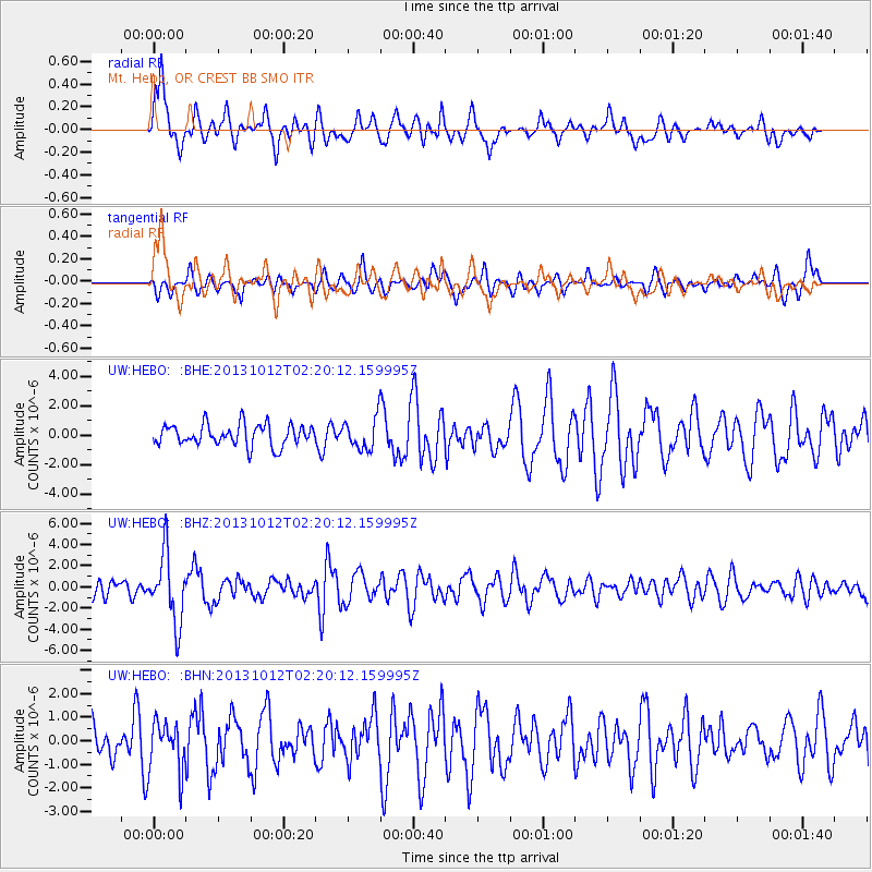
HEBO Mt. Hebo, OR CREST BB SMO - Earthquake Result Viewer
*The percent match for this event was below the threshold and hence no stack was calculated.
| Earthquake location: |
Near Coast Of Venezuela |
| Earthquake latitude/longitude: |
10.9/-62.3 |
| Earthquake time(UTC): |
2013/10/12 (285) 02:10:27 GMT |
| Earthquake Depth: |
63 km |
| Earthquake Magnitude: |
6.0 MWW, 6.0 MWW, 6.0 MWB, 6.0 MWC, 6.0 MI |
| Earthquake Catalog/Contributor: |
NEIC PDE/NEIC COMCAT |
|
| Network: |
UW Pacific Northwest Regional Seismic Network |
| Station: |
HEBO Mt. Hebo, OR CREST BB SMO |
| Lat/Lon: |
45.21 N/123.76 W |
| Elevation: |
875 m |
|
| Distance: |
62.3 deg |
| Az: |
315.476 deg |
| Baz: |
103.008 deg |
| Ray Param: |
$rayparam |
*The percent match for this event was below the threshold and hence was not used in the summary stack. |
|
| Radial Match: |
78.99251 % |
| Radial Bump: |
400 |
| Transverse Match: |
45.336918 % |
| Transverse Bump: |
380 |
| SOD ConfigId: |
626651 |
| Insert Time: |
2014-04-19 01:59:17.267 +0000 |
| GWidth: |
2.5 |
| Max Bumps: |
400 |
| Tol: |
0.001 |
|
Signal To Noise
| Channel | StoN | STA | LTA |
| UW:HEBO: :BHZ:20131012T02:20:12.159995Z | 4.1696353 | 3.2194312E-6 | 7.7211337E-7 |
| UW:HEBO: :BHN:20131012T02:20:12.159995Z | 0.9096077 | 1.0384895E-6 | 1.1416894E-6 |
| UW:HEBO: :BHE:20131012T02:20:12.159995Z | 1.5042683 | 1.0865126E-6 | 7.222865E-7 |
| Arrivals |
| Ps | |
| PpPs | |
| PsPs/PpSs | |


