You are here: Home > Network List > UW - Pacific Northwest Regional Seismic Network Stations List
> Station LEBA Lebam, WA, USA > Earthquake Result Viewer
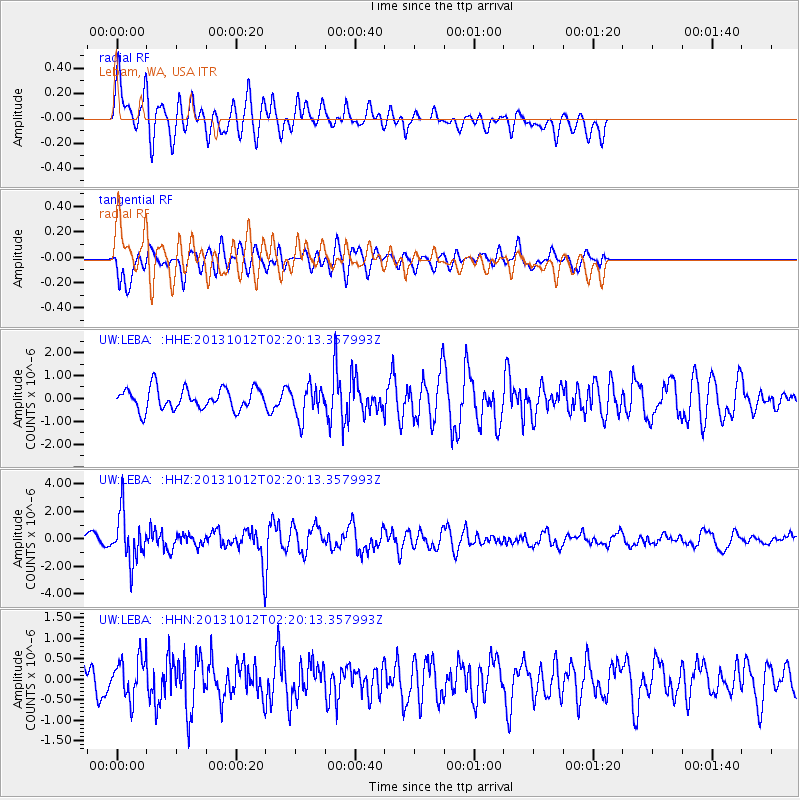
LEBA Lebam, WA, USA - Earthquake Result Viewer
*The percent match for this event was below the threshold and hence no stack was calculated.
| Earthquake location: |
Near Coast Of Venezuela |
| Earthquake latitude/longitude: |
10.9/-62.3 |
| Earthquake time(UTC): |
2013/10/12 (285) 02:10:27 GMT |
| Earthquake Depth: |
63 km |
| Earthquake Magnitude: |
6.0 MWW, 6.0 MWW, 6.0 MWB, 6.0 MWC, 6.0 MI |
| Earthquake Catalog/Contributor: |
NEIC PDE/NEIC COMCAT |
|
| Network: |
UW Pacific Northwest Regional Seismic Network |
| Station: |
LEBA Lebam, WA, USA |
| Lat/Lon: |
46.55 N/123.56 W |
| Elevation: |
73 m |
|
| Distance: |
62.5 deg |
| Az: |
316.974 deg |
| Baz: |
103.84 deg |
| Ray Param: |
$rayparam |
*The percent match for this event was below the threshold and hence was not used in the summary stack. |
|
| Radial Match: |
73.22393 % |
| Radial Bump: |
400 |
| Transverse Match: |
63.73562 % |
| Transverse Bump: |
400 |
| SOD ConfigId: |
626651 |
| Insert Time: |
2014-04-19 01:59:32.331 +0000 |
| GWidth: |
2.5 |
| Max Bumps: |
400 |
| Tol: |
0.001 |
|
Signal To Noise
| Channel | StoN | STA | LTA |
| UW:LEBA: :HHZ:20131012T02:20:13.357993Z | 3.175495 | 1.7541296E-6 | 5.5239565E-7 |
| UW:LEBA: :HHN:20131012T02:20:13.357993Z | 1.3870732 | 4.7444897E-7 | 3.4205044E-7 |
| UW:LEBA: :HHE:20131012T02:20:13.357993Z | 1.4749488 | 6.7949384E-7 | 4.606898E-7 |
| Arrivals |
| Ps | |
| PpPs | |
| PsPs/PpSs | |


