You are here: Home > Network List > PF - Volcanologic Network of Piton de Fournaise-OVPF Stations List
> Station HIM cratere Himiltrude > Earthquake Result Viewer
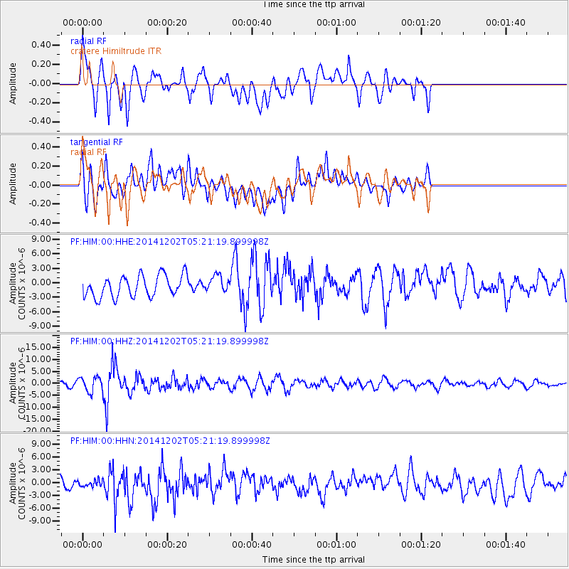
HIM cratere Himiltrude - Earthquake Result Viewer
*The percent match for this event was below the threshold and hence no stack was calculated.
| Earthquake location: |
Mindanao, Philippines |
| Earthquake latitude/longitude: |
6.1/123.1 |
| Earthquake time(UTC): |
2014/12/02 (336) 05:11:31 GMT |
| Earthquake Depth: |
614 km |
| Earthquake Magnitude: |
6.6 MWW, 6.6 MWC, 6.6 MWB |
| Earthquake Catalog/Contributor: |
NEIC PDE/NEIC COMCAT |
|
| Network: |
PF Volcanologic Network of Piton de Fournaise-OVPF |
| Station: |
HIM cratere Himiltrude |
| Lat/Lon: |
21.21 S/55.72 E |
| Elevation: |
1958 m |
|
| Distance: |
71.4 deg |
| Az: |
245.34 deg |
| Baz: |
75.594 deg |
| Ray Param: |
$rayparam |
*The percent match for this event was below the threshold and hence was not used in the summary stack. |
|
| Radial Match: |
64.63458 % |
| Radial Bump: |
400 |
| Transverse Match: |
59.452057 % |
| Transverse Bump: |
400 |
| SOD ConfigId: |
3390531 |
| Insert Time: |
2019-04-15 07:18:15.000 +0000 |
| GWidth: |
2.5 |
| Max Bumps: |
400 |
| Tol: |
0.001 |
|
Signal To Noise
| Channel | StoN | STA | LTA |
| PF:HIM:00:HHZ:20141202T05:21:19.899998Z | 3.0759647 | 3.3014421E-6 | 1.073303E-6 |
| PF:HIM:00:HHN:20141202T05:21:19.899998Z | 0.5625224 | 8.2710545E-7 | 1.4703511E-6 |
| PF:HIM:00:HHE:20141202T05:21:19.899998Z | 0.81958985 | 1.8077494E-6 | 2.2056756E-6 |
| Arrivals |
| Ps | |
| PpPs | |
| PsPs/PpSs | |


