You are here: Home > Network List > XJ13 - CRAFTI Stations List
> Station LN34 Lwondulwo boma > Earthquake Result Viewer
LN34 Lwondulwo boma - Earthquake Result Viewer
| Earthquake location: |
Mindanao, Philippines |
| Earthquake latitude/longitude: |
6.1/123.1 |
| Earthquake time(UTC): |
2014/12/02 (336) 05:11:31 GMT |
| Earthquake Depth: |
614 km |
| Earthquake Magnitude: |
6.6 MWW, 6.6 MWC, 6.6 MWB |
| Earthquake Catalog/Contributor: |
NEIC PDE/NEIC COMCAT |
|
| Network: |
XJ CRAFTI |
| Station: |
LN34 Lwondulwo boma |
| Lat/Lon: |
2.75 S/36.05 E |
| Elevation: |
1066 m |
|
| Distance: |
87.4 deg |
| Az: |
266.971 deg |
| Baz: |
83.808 deg |
| Ray Param: |
0.04171942 |
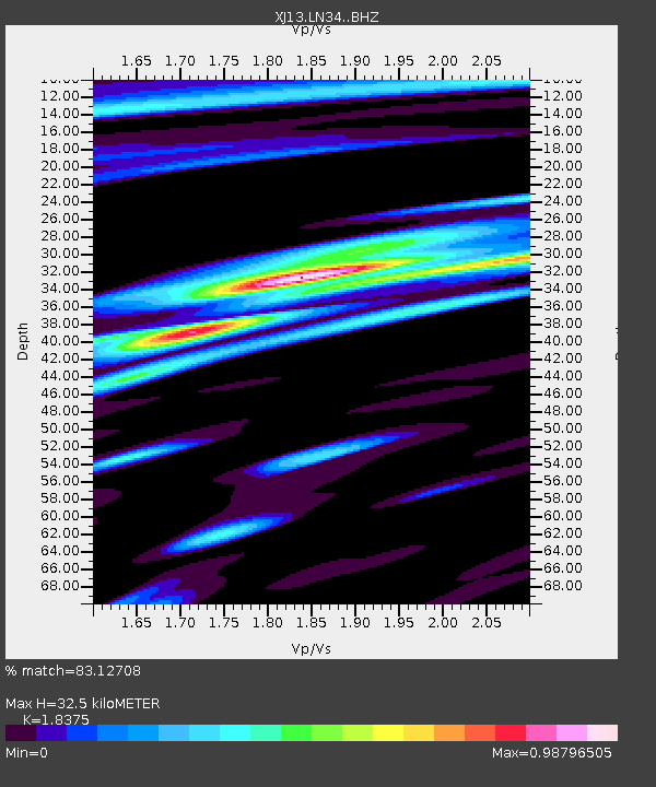
| Estimated Moho Depth: |
32.5 km |
| Estimated Crust Vp/Vs: |
1.84 |
| Assumed Crust Vp: |
6.601 km/s |
| Estimated Crust Vs: |
3.592 km/s |
| Estimated Crust Poisson's Ratio: |
0.29 |
|
| Radial Match: |
83.12708 % |
| Radial Bump: |
400 |
| Transverse Match: |
70.262375 % |
| Transverse Bump: |
400 |
| SOD ConfigId: |
3390531 |
| Insert Time: |
2019-04-15 07:18:50.797 +0000 |
| GWidth: |
2.5 |
| Max Bumps: |
400 |
| Tol: |
0.001 |
|

Signal To Noise
| Channel | StoN | STA | LTA |
| XJ:LN34: :BHZ:20141202T05:22:42.999973Z | 2.9617455 | 4.6664758E-7 | 1.5755829E-7 |
| XJ:LN34: :BHN:20141202T05:22:42.999973Z | 0.95708096 | 1.4193563E-7 | 1.4830056E-7 |
| XJ:LN34: :BHE:20141202T05:22:42.999973Z | 1.4048761 | 1.7688552E-7 | 1.2590827E-7 |
| Arrivals |
| Ps | 4.2 SECOND |
| PpPs | 14 SECOND |
| PsPs/PpSs | 18 SECOND |


