You are here: Home > Network List > XJ13 - CRAFTI Stations List
> Station PR63 Meshili Boma > Earthquake Result Viewer
PR63 Meshili Boma - Earthquake Result Viewer
| Earthquake location: |
Mindanao, Philippines |
| Earthquake latitude/longitude: |
6.1/123.1 |
| Earthquake time(UTC): |
2014/12/02 (336) 05:11:31 GMT |
| Earthquake Depth: |
614 km |
| Earthquake Magnitude: |
6.6 MWW, 6.6 MWC, 6.6 MWB |
| Earthquake Catalog/Contributor: |
NEIC PDE/NEIC COMCAT |
|
| Network: |
XJ CRAFTI |
| Station: |
PR63 Meshili Boma |
| Lat/Lon: |
2.99 S/35.51 E |
| Elevation: |
1362 m |
|
| Distance: |
87.9 deg |
| Az: |
266.79 deg |
| Baz: |
83.827 deg |
| Ray Param: |
0.041679397 |
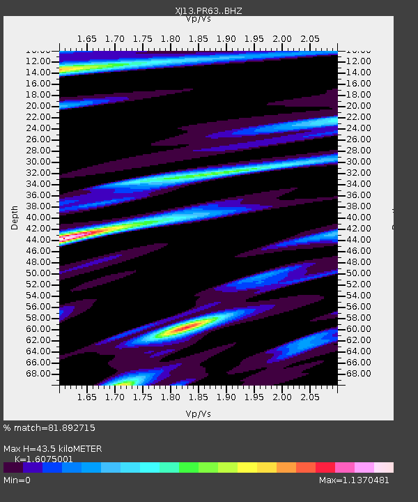
| Estimated Moho Depth: |
43.5 km |
| Estimated Crust Vp/Vs: |
1.61 |
| Assumed Crust Vp: |
6.576 km/s |
| Estimated Crust Vs: |
4.091 km/s |
| Estimated Crust Poisson's Ratio: |
0.18 |
|
| Radial Match: |
81.892715 % |
| Radial Bump: |
400 |
| Transverse Match: |
68.20323 % |
| Transverse Bump: |
400 |
| SOD ConfigId: |
3390531 |
| Insert Time: |
2019-04-15 07:18:58.855 +0000 |
| GWidth: |
2.5 |
| Max Bumps: |
400 |
| Tol: |
0.001 |
|

Signal To Noise
| Channel | StoN | STA | LTA |
| XJ:PR63: :BHZ:20141202T05:22:45.60001Z | 5.0639515 | 5.181861E-7 | 1.0232841E-7 |
| XJ:PR63: :BHN:20141202T05:22:45.60001Z | 0.6012914 | 1.3467053E-7 | 2.2396883E-7 |
| XJ:PR63: :BHE:20141202T05:22:45.60001Z | 1.2813504 | 2.476168E-7 | 1.9324678E-7 |
| Arrivals |
| Ps | 4.1 SECOND |
| PpPs | 17 SECOND |
| PsPs/PpSs | 21 SECOND |


