You are here: Home > Network List > MB - Montana Regional Seismic Network Stations List
> Station JTMT Jette Lake, Montana > Earthquake Result Viewer
JTMT Jette Lake, Montana - Earthquake Result Viewer
| Earthquake location: |
Crete, Greece |
| Earthquake latitude/longitude: |
35.5/23.3 |
| Earthquake time(UTC): |
2013/10/12 (285) 13:11:53 GMT |
| Earthquake Depth: |
40 km |
| Earthquake Magnitude: |
6.6 MWW, 6.5 MWB, 6.6 MWW, 6.7 MWC |
| Earthquake Catalog/Contributor: |
NEIC PDE/NEIC COMCAT |
|
| Network: |
MB Montana Regional Seismic Network |
| Station: |
JTMT Jette Lake, Montana |
| Lat/Lon: |
47.75 N/114.28 W |
| Elevation: |
1469 m |
|
| Distance: |
88.8 deg |
| Az: |
332.888 deg |
| Baz: |
33.429 deg |
| Ray Param: |
0.042244125 |
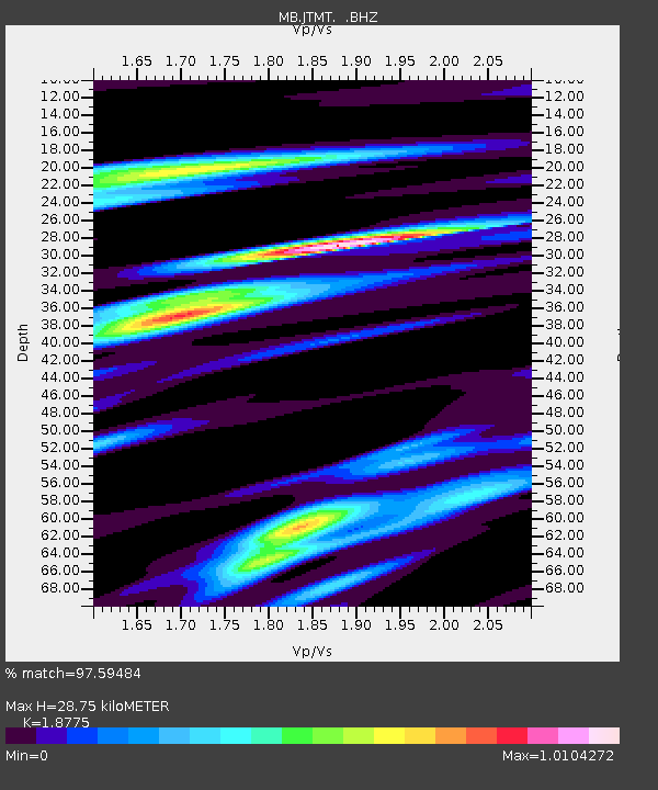
| Estimated Moho Depth: |
28.75 km |
| Estimated Crust Vp/Vs: |
1.88 |
| Assumed Crust Vp: |
6.622 km/s |
| Estimated Crust Vs: |
3.527 km/s |
| Estimated Crust Poisson's Ratio: |
0.30 |
|
| Radial Match: |
97.59484 % |
| Radial Bump: |
256 |
| Transverse Match: |
86.75926 % |
| Transverse Bump: |
321 |
| SOD ConfigId: |
626651 |
| Insert Time: |
2014-04-19 02:19:20.263 +0000 |
| GWidth: |
2.5 |
| Max Bumps: |
400 |
| Tol: |
0.001 |
|

Signal To Noise
| Channel | StoN | STA | LTA |
| MB:JTMT: :BHZ:20131012T13:24:11.894983Z | 27.355972 | 2.5448664E-6 | 9.3027815E-8 |
| MB:JTMT: :BHN:20131012T13:24:11.894983Z | 6.2493763 | 7.9018326E-7 | 1.2644195E-7 |
| MB:JTMT: :BHE:20131012T13:24:11.894983Z | 4.1030297 | 6.3475045E-7 | 1.5470287E-7 |
| Arrivals |
| Ps | 3.9 SECOND |
| PpPs | 12 SECOND |
| PsPs/PpSs | 16 SECOND |


