You are here: Home > Network List > TA - USArray Transportable Network (new EarthScope stations) Stations List
> Station D62A Allapoint, Allagash, ME, USA > Earthquake Result Viewer
D62A Allapoint, Allagash, ME, USA - Earthquake Result Viewer
| Earthquake location: |
Crete, Greece |
| Earthquake latitude/longitude: |
35.5/23.3 |
| Earthquake time(UTC): |
2013/10/12 (285) 13:11:53 GMT |
| Earthquake Depth: |
40 km |
| Earthquake Magnitude: |
6.6 MWW, 6.5 MWB, 6.6 MWW, 6.7 MWC |
| Earthquake Catalog/Contributor: |
NEIC PDE/NEIC COMCAT |
|
| Network: |
TA USArray Transportable Network (new EarthScope stations) |
| Station: |
D62A Allapoint, Allagash, ME, USA |
| Lat/Lon: |
47.08 N/69.05 W |
| Elevation: |
189 m |
|
| Distance: |
66.4 deg |
| Az: |
311.843 deg |
| Baz: |
62.788 deg |
| Ray Param: |
0.057545755 |
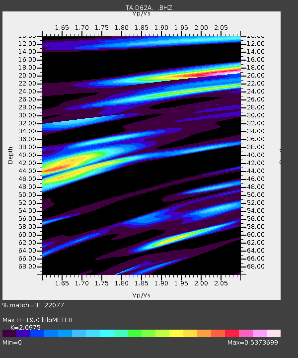
| Estimated Moho Depth: |
19.0 km |
| Estimated Crust Vp/Vs: |
2.10 |
| Assumed Crust Vp: |
6.419 km/s |
| Estimated Crust Vs: |
3.06 km/s |
| Estimated Crust Poisson's Ratio: |
0.35 |
|
| Radial Match: |
81.22077 % |
| Radial Bump: |
358 |
| Transverse Match: |
68.244835 % |
| Transverse Bump: |
400 |
| SOD ConfigId: |
626651 |
| Insert Time: |
2014-04-19 02:27:09.297 +0000 |
| GWidth: |
2.5 |
| Max Bumps: |
400 |
| Tol: |
0.001 |
|

Signal To Noise
| Channel | StoN | STA | LTA |
| TA:D62A: :BHZ:20131012T13:22:07.699976Z | 9.264979 | 1.6778108E-6 | 1.8109169E-7 |
| TA:D62A: :BHN:20131012T13:22:07.699976Z | 1.4772192 | 4.30829E-7 | 2.9164866E-7 |
| TA:D62A: :BHE:20131012T13:22:07.699976Z | 3.0440762 | 7.75774E-7 | 2.548471E-7 |
| Arrivals |
| Ps | 3.4 SECOND |
| PpPs | 8.9 SECOND |
| PsPs/PpSs | 12 SECOND |


