You are here: Home > Network List > AZ - ANZA Regional Network Stations List
> Station SMER AZ.SMER > Earthquake Result Viewer
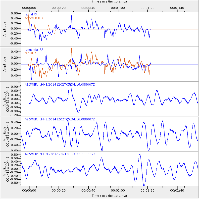
SMER AZ.SMER - Earthquake Result Viewer
*The percent match for this event was below the threshold and hence no stack was calculated.
| Earthquake location: |
Southeast Of Galapagos Islands |
| Earthquake latitude/longitude: |
-6.2/-86.9 |
| Earthquake time(UTC): |
2014/12/02 (336) 05:26:53 GMT |
| Earthquake Depth: |
574 km |
| Earthquake Magnitude: |
5.5 MW |
| Earthquake Catalog/Contributor: |
ISC/ISC |
|
| Network: |
AZ ANZA Regional Network |
| Station: |
SMER AZ.SMER |
| Lat/Lon: |
33.46 N/117.17 W |
| Elevation: |
355 m |
|
| Distance: |
48.8 deg |
| Az: |
325.93 deg |
| Baz: |
138.221 deg |
| Ray Param: |
$rayparam |
*The percent match for this event was below the threshold and hence was not used in the summary stack. |
|
| Radial Match: |
57.484077 % |
| Radial Bump: |
400 |
| Transverse Match: |
46.70654 % |
| Transverse Bump: |
400 |
| SOD ConfigId: |
3390531 |
| Insert Time: |
2019-04-15 07:23:05.901 +0000 |
| GWidth: |
2.5 |
| Max Bumps: |
400 |
| Tol: |
0.001 |
|
Signal To Noise
| Channel | StoN | STA | LTA |
| AZ:SMER: :HHZ:20141202T05:34:16.088007Z | 0.50974536 | 1.3058258E-7 | 2.5617217E-7 |
| AZ:SMER: :HHN:20141202T05:34:16.088007Z | 1.3918772 | 3.328299E-7 | 2.3912307E-7 |
| AZ:SMER: :HHE:20141202T05:34:16.088007Z | 3.7597759 | 6.0337E-7 | 1.604803E-7 |
| Arrivals |
| Ps | |
| PpPs | |
| PsPs/PpSs | |


