You are here: Home > Network List > TA - USArray Transportable Network (new EarthScope stations) Stations List
> Station G53A Haliburton, ON, CAN > Earthquake Result Viewer
G53A Haliburton, ON, CAN - Earthquake Result Viewer
| Earthquake location: |
Crete, Greece |
| Earthquake latitude/longitude: |
35.5/23.3 |
| Earthquake time(UTC): |
2013/10/12 (285) 13:11:53 GMT |
| Earthquake Depth: |
40 km |
| Earthquake Magnitude: |
6.6 MWW, 6.5 MWB, 6.6 MWW, 6.7 MWC |
| Earthquake Catalog/Contributor: |
NEIC PDE/NEIC COMCAT |
|
| Network: |
TA USArray Transportable Network (new EarthScope stations) |
| Station: |
G53A Haliburton, ON, CAN |
| Lat/Lon: |
45.12 N/78.62 W |
| Elevation: |
333 m |
|
| Distance: |
73.2 deg |
| Az: |
313.628 deg |
| Baz: |
56.521 deg |
| Ray Param: |
0.053115714 |
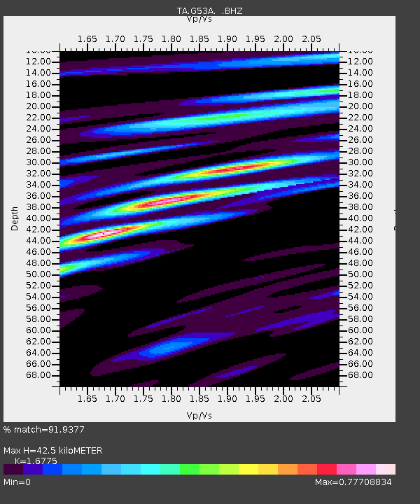
| Estimated Moho Depth: |
42.5 km |
| Estimated Crust Vp/Vs: |
1.68 |
| Assumed Crust Vp: |
6.577 km/s |
| Estimated Crust Vs: |
3.921 km/s |
| Estimated Crust Poisson's Ratio: |
0.22 |
|
| Radial Match: |
91.9377 % |
| Radial Bump: |
400 |
| Transverse Match: |
63.629063 % |
| Transverse Bump: |
400 |
| SOD ConfigId: |
626651 |
| Insert Time: |
2014-04-19 02:29:18.764 +0000 |
| GWidth: |
2.5 |
| Max Bumps: |
400 |
| Tol: |
0.001 |
|

Signal To Noise
| Channel | StoN | STA | LTA |
| TA:G53A: :BHZ:20131012T13:22:48.974023Z | 3.4535644 | 1.188085E-6 | 3.4401705E-7 |
| TA:G53A: :BHN:20131012T13:22:48.974023Z | 2.0839841 | 4.481839E-7 | 2.1506109E-7 |
| TA:G53A: :BHE:20131012T13:22:48.974023Z | 1.8527893 | 3.8162545E-7 | 2.0597348E-7 |
| Arrivals |
| Ps | 4.5 SECOND |
| PpPs | 17 SECOND |
| PsPs/PpSs | 21 SECOND |


