You are here: Home > Network List > TA - USArray Transportable Network (new EarthScope stations) Stations List
> Station I45A Fountain, MI, USA > Earthquake Result Viewer
I45A Fountain, MI, USA - Earthquake Result Viewer
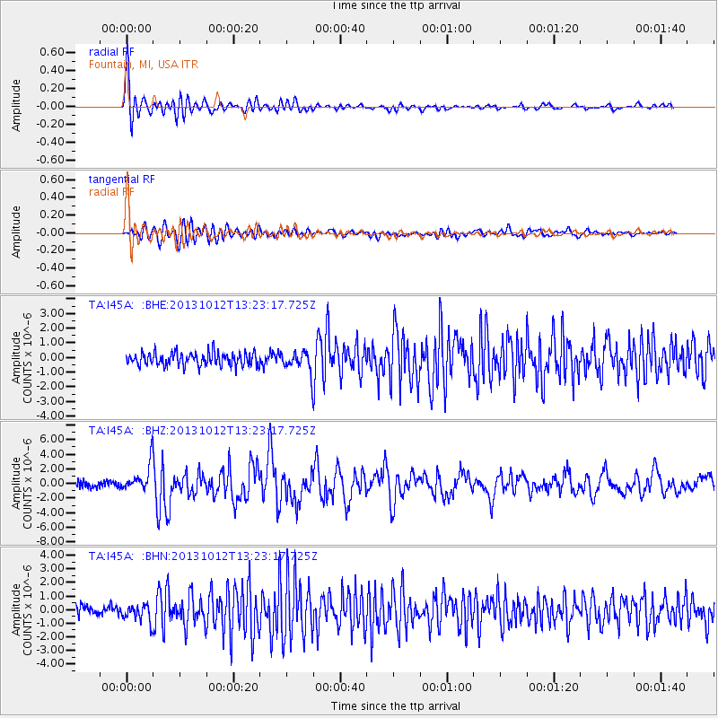
| Earthquake location: |
Crete, Greece |
| Earthquake latitude/longitude: |
35.5/23.3 |
| Earthquake time(UTC): |
2013/10/12 (285) 13:11:53 GMT |
| Earthquake Depth: |
40 km |
| Earthquake Magnitude: |
6.6 MWW, 6.5 MWB, 6.6 MWW, 6.7 MWC |
| Earthquake Catalog/Contributor: |
NEIC PDE/NEIC COMCAT |
|
| Network: |
TA USArray Transportable Network (new EarthScope stations) |
| Station: |
I45A Fountain, MI, USA |
| Lat/Lon: |
44.04 N/86.23 W |
| Elevation: |
215 m |
|
| Distance: |
78.2 deg |
| Az: |
316.007 deg |
| Baz: |
51.781 deg |
| Ray Param: |
0.049732685 |
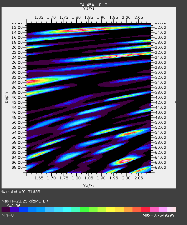
| Estimated Moho Depth: |
23.25 km |
| Estimated Crust Vp/Vs: |
1.96 |
| Assumed Crust Vp: |
6.53 km/s |
| Estimated Crust Vs: |
3.332 km/s |
| Estimated Crust Poisson's Ratio: |
0.32 |
|
| Radial Match: |
91.31638 % |
| Radial Bump: |
400 |
| Transverse Match: |
81.66055 % |
| Transverse Bump: |
400 |
| SOD ConfigId: |
626651 |
| Insert Time: |
2014-04-19 02:31:08.630 +0000 |
| GWidth: |
2.5 |
| Max Bumps: |
400 |
| Tol: |
0.001 |
|
Signal To Noise
| Channel | StoN | STA | LTA |
| TA:I45A: :BHZ:20131012T13:23:17.725Z | 5.264464 | 1.9375766E-6 | 3.6804823E-7 |
| TA:I45A: :BHN:20131012T13:23:17.725Z | 1.5648371 | 6.342586E-7 | 4.053192E-7 |
| TA:I45A: :BHE:20131012T13:23:17.725Z | 1.584439 | 6.9495576E-7 | 4.3861314E-7 |
| Arrivals |
| Ps | 3.5 SECOND |
| PpPs | 10 SECOND |
| PsPs/PpSs | 14 SECOND |


