You are here: Home > Network List > TA - USArray Transportable Network (new EarthScope stations) Stations List
> Station MSTX Muleshoe, TX, USA > Earthquake Result Viewer
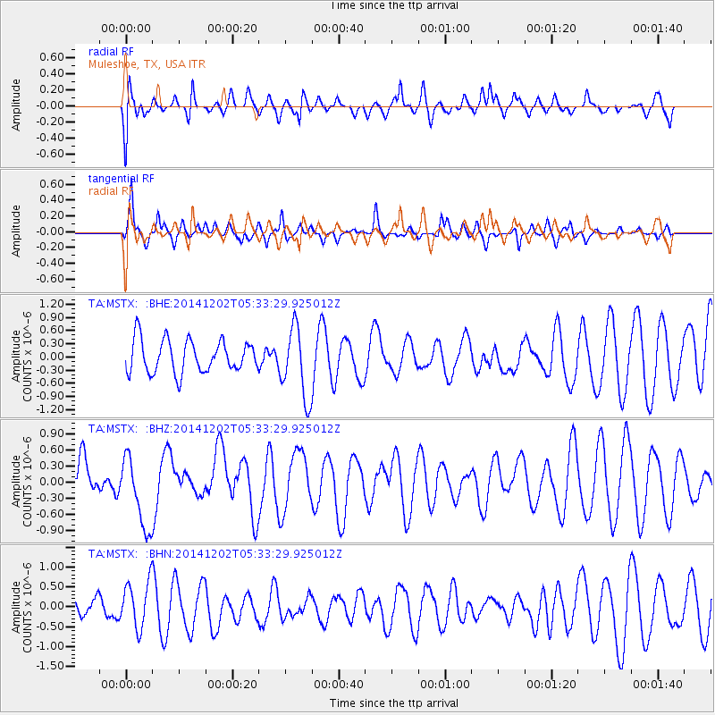
MSTX Muleshoe, TX, USA - Earthquake Result Viewer
*The percent match for this event was below the threshold and hence no stack was calculated.
| Earthquake location: |
Southeast Of Galapagos Islands |
| Earthquake latitude/longitude: |
-6.2/-86.9 |
| Earthquake time(UTC): |
2014/12/02 (336) 05:26:53 GMT |
| Earthquake Depth: |
574 km |
| Earthquake Magnitude: |
5.5 MW |
| Earthquake Catalog/Contributor: |
ISC/ISC |
|
| Network: |
TA USArray Transportable Network (new EarthScope stations) |
| Station: |
MSTX Muleshoe, TX, USA |
| Lat/Lon: |
33.97 N/102.77 W |
| Elevation: |
1167 m |
|
| Distance: |
42.7 deg |
| Az: |
340.424 deg |
| Baz: |
156.368 deg |
| Ray Param: |
$rayparam |
*The percent match for this event was below the threshold and hence was not used in the summary stack. |
|
| Radial Match: |
53.621506 % |
| Radial Bump: |
400 |
| Transverse Match: |
72.41217 % |
| Transverse Bump: |
400 |
| SOD ConfigId: |
3390531 |
| Insert Time: |
2019-04-15 07:28:34.817 +0000 |
| GWidth: |
2.5 |
| Max Bumps: |
400 |
| Tol: |
0.001 |
|
Signal To Noise
| Channel | StoN | STA | LTA |
| TA:MSTX: :BHZ:20141202T05:33:29.925012Z | 1.9052316 | 6.7689604E-7 | 3.5528282E-7 |
| TA:MSTX: :BHN:20141202T05:33:29.925012Z | 2.5465865 | 5.9289374E-7 | 2.32819E-7 |
| TA:MSTX: :BHE:20141202T05:33:29.925012Z | 2.2080593 | 8.162064E-7 | 3.6964875E-7 |
| Arrivals |
| Ps | |
| PpPs | |
| PsPs/PpSs | |


