You are here: Home > Network List > TA - USArray Transportable Network (new EarthScope stations) Stations List
> Station N41A Harden Midland Farm, Stronghurst, IL, USA > Earthquake Result Viewer
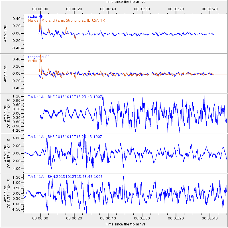
N41A Harden Midland Farm, Stronghurst, IL, USA - Earthquake Result Viewer

| Earthquake location: |
Crete, Greece |
| Earthquake latitude/longitude: |
35.5/23.3 |
| Earthquake time(UTC): |
2013/10/12 (285) 13:11:53 GMT |
| Earthquake Depth: |
40 km |
| Earthquake Magnitude: |
6.6 MWW, 6.5 MWB, 6.6 MWW, 6.7 MWC |
| Earthquake Catalog/Contributor: |
NEIC PDE/NEIC COMCAT |
|
| Network: |
TA USArray Transportable Network (new EarthScope stations) |
| Station: |
N41A Harden Midland Farm, Stronghurst, IL, USA |
| Lat/Lon: |
40.71 N/90.86 W |
| Elevation: |
226 m |
|
| Distance: |
83.0 deg |
| Az: |
315.64 deg |
| Baz: |
48.616 deg |
| Ray Param: |
0.0464581 |
| Estimated Moho Depth: |
37.0 km |
| Estimated Crust Vp/Vs: |
1.84 |
| Assumed Crust Vp: |
6.498 km/s |
| Estimated Crust Vs: |
3.526 km/s |
| Estimated Crust Poisson's Ratio: |
0.29 |
|
| Radial Match: |
85.12637 % |
| Radial Bump: |
386 |
| Transverse Match: |
68.9519 % |
| Transverse Bump: |
400 |
| SOD ConfigId: |
626651 |
| Insert Time: |
2014-04-19 02:35:46.464 +0000 |
| GWidth: |
2.5 |
| Max Bumps: |
400 |
| Tol: |
0.001 |
|
Signal To Noise
| Channel | StoN | STA | LTA |
| TA:N41A: :BHZ:20131012T13:23:43.100Z | 6.5516653 | 1.5208891E-6 | 2.321378E-7 |
| TA:N41A: :BHN:20131012T13:23:43.100Z | 2.3538568 | 5.2099733E-7 | 2.2133776E-7 |
| TA:N41A: :BHE:20131012T13:23:43.100Z | 2.1171064 | 4.525026E-7 | 2.1373636E-7 |
| Arrivals |
| Ps | 4.9 SECOND |
| PpPs | 16 SECOND |
| PsPs/PpSs | 21 SECOND |


