You are here: Home > Network List > TA - USArray Transportable Network (new EarthScope stations) Stations List
> Station O48A Farmland, IN, USA > Earthquake Result Viewer
O48A Farmland, IN, USA - Earthquake Result Viewer
| Earthquake location: |
Crete, Greece |
| Earthquake latitude/longitude: |
35.5/23.3 |
| Earthquake time(UTC): |
2013/10/12 (285) 13:11:53 GMT |
| Earthquake Depth: |
40 km |
| Earthquake Magnitude: |
6.6 MWW, 6.5 MWB, 6.6 MWW, 6.7 MWC |
| Earthquake Catalog/Contributor: |
NEIC PDE/NEIC COMCAT |
|
| Network: |
TA USArray Transportable Network (new EarthScope stations) |
| Station: |
O48A Farmland, IN, USA |
| Lat/Lon: |
40.26 N/85.16 W |
| Elevation: |
300 m |
|
| Distance: |
79.9 deg |
| Az: |
312.479 deg |
| Baz: |
51.833 deg |
| Ray Param: |
0.048571747 |
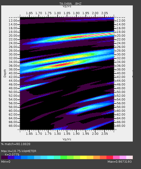
| Estimated Moho Depth: |
18.75 km |
| Estimated Crust Vp/Vs: |
2.08 |
| Assumed Crust Vp: |
6.498 km/s |
| Estimated Crust Vs: |
3.128 km/s |
| Estimated Crust Poisson's Ratio: |
0.35 |
|
| Radial Match: |
90.18828 % |
| Radial Bump: |
400 |
| Transverse Match: |
62.673843 % |
| Transverse Bump: |
400 |
| SOD ConfigId: |
626651 |
| Insert Time: |
2014-04-19 02:36:35.976 +0000 |
| GWidth: |
2.5 |
| Max Bumps: |
400 |
| Tol: |
0.001 |
|
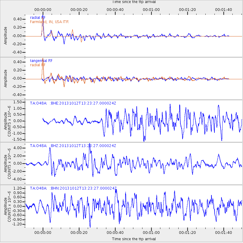
Signal To Noise
| Channel | StoN | STA | LTA |
| TA:O48A: :BHZ:20131012T13:23:27.000024Z | 5.9232917 | 1.5337913E-6 | 2.589424E-7 |
| TA:O48A: :BHN:20131012T13:23:27.000024Z | 1.6875389 | 4.068447E-7 | 2.410876E-7 |
| TA:O48A: :BHE:20131012T13:23:27.000024Z | 3.048499 | 4.399325E-7 | 1.4431119E-7 |
| Arrivals |
| Ps | 3.2 SECOND |
| PpPs | 8.7 SECOND |
| PsPs/PpSs | 12 SECOND |


