You are here: Home > Network List > TA - USArray Transportable Network (new EarthScope stations) Stations List
> Station Q48A North Vernon, IN, USA > Earthquake Result Viewer
Q48A North Vernon, IN, USA - Earthquake Result Viewer

| Earthquake location: |
Crete, Greece |
| Earthquake latitude/longitude: |
35.5/23.3 |
| Earthquake time(UTC): |
2013/10/12 (285) 13:11:53 GMT |
| Earthquake Depth: |
40 km |
| Earthquake Magnitude: |
6.6 MWW, 6.5 MWB, 6.6 MWW, 6.7 MWC |
| Earthquake Catalog/Contributor: |
NEIC PDE/NEIC COMCAT |
|
| Network: |
TA USArray Transportable Network (new EarthScope stations) |
| Station: |
Q48A North Vernon, IN, USA |
| Lat/Lon: |
38.93 N/85.73 W |
| Elevation: |
185 m |
|
| Distance: |
81.1 deg |
| Az: |
311.706 deg |
| Baz: |
51.34 deg |
| Ray Param: |
0.047770135 |
| Estimated Moho Depth: |
65.0 km |
| Estimated Crust Vp/Vs: |
2.05 |
| Assumed Crust Vp: |
6.498 km/s |
| Estimated Crust Vs: |
3.166 km/s |
| Estimated Crust Poisson's Ratio: |
0.34 |
|
| Radial Match: |
92.2058 % |
| Radial Bump: |
344 |
| Transverse Match: |
71.261734 % |
| Transverse Bump: |
400 |
| SOD ConfigId: |
626651 |
| Insert Time: |
2014-04-19 02:38:00.379 +0000 |
| GWidth: |
2.5 |
| Max Bumps: |
400 |
| Tol: |
0.001 |
|
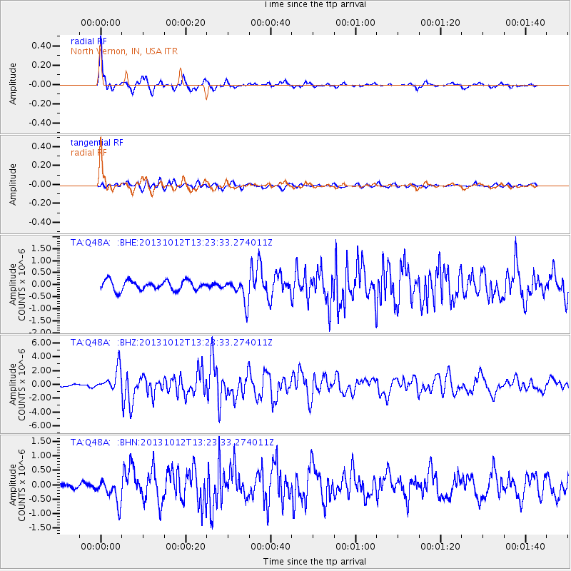
Signal To Noise
| Channel | StoN | STA | LTA |
| TA:Q48A: :BHZ:20131012T13:23:33.274011Z | 5.422436 | 1.7101715E-6 | 3.1538804E-7 |
| TA:Q48A: :BHN:20131012T13:23:33.274011Z | 1.9941876 | 4.344104E-7 | 2.1783828E-7 |
| TA:Q48A: :BHE:20131012T13:23:33.274011Z | 2.5800018 | 5.1282046E-7 | 1.9876748E-7 |
| Arrivals |
| Ps | 11 SECOND |
| PpPs | 30 SECOND |
| PsPs/PpSs | 41 SECOND |


