You are here: Home > Network List > TA - USArray Transportable Network (new EarthScope stations) Stations List
> Station Q51A Peebles, OH, USA > Earthquake Result Viewer
Q51A Peebles, OH, USA - Earthquake Result Viewer
| Earthquake location: |
Crete, Greece |
| Earthquake latitude/longitude: |
35.5/23.3 |
| Earthquake time(UTC): |
2013/10/12 (285) 13:11:53 GMT |
| Earthquake Depth: |
40 km |
| Earthquake Magnitude: |
6.6 MWW, 6.5 MWB, 6.6 MWW, 6.7 MWC |
| Earthquake Catalog/Contributor: |
NEIC PDE/NEIC COMCAT |
|
| Network: |
TA USArray Transportable Network (new EarthScope stations) |
| Station: |
Q51A Peebles, OH, USA |
| Lat/Lon: |
39.03 N/83.35 W |
| Elevation: |
362 m |
|
| Distance: |
79.6 deg |
| Az: |
310.622 deg |
| Baz: |
52.653 deg |
| Ray Param: |
0.048812352 |
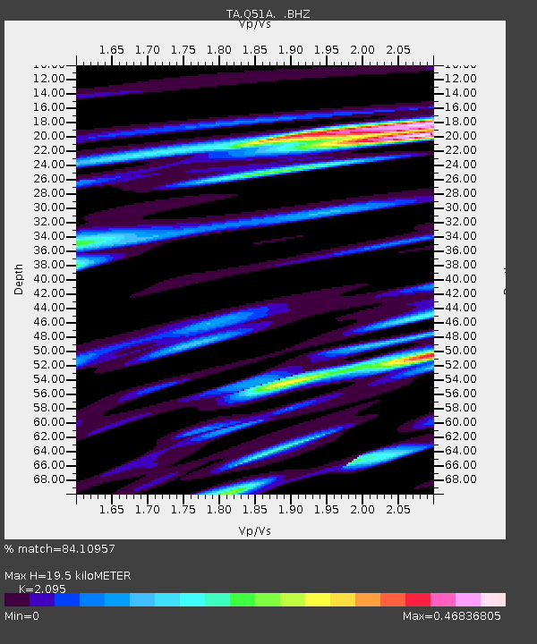
| Estimated Moho Depth: |
19.5 km |
| Estimated Crust Vp/Vs: |
2.10 |
| Assumed Crust Vp: |
6.232 km/s |
| Estimated Crust Vs: |
2.975 km/s |
| Estimated Crust Poisson's Ratio: |
0.35 |
|
| Radial Match: |
84.10957 % |
| Radial Bump: |
400 |
| Transverse Match: |
75.5536 % |
| Transverse Bump: |
400 |
| SOD ConfigId: |
626651 |
| Insert Time: |
2014-04-19 02:38:06.682 +0000 |
| GWidth: |
2.5 |
| Max Bumps: |
400 |
| Tol: |
0.001 |
|
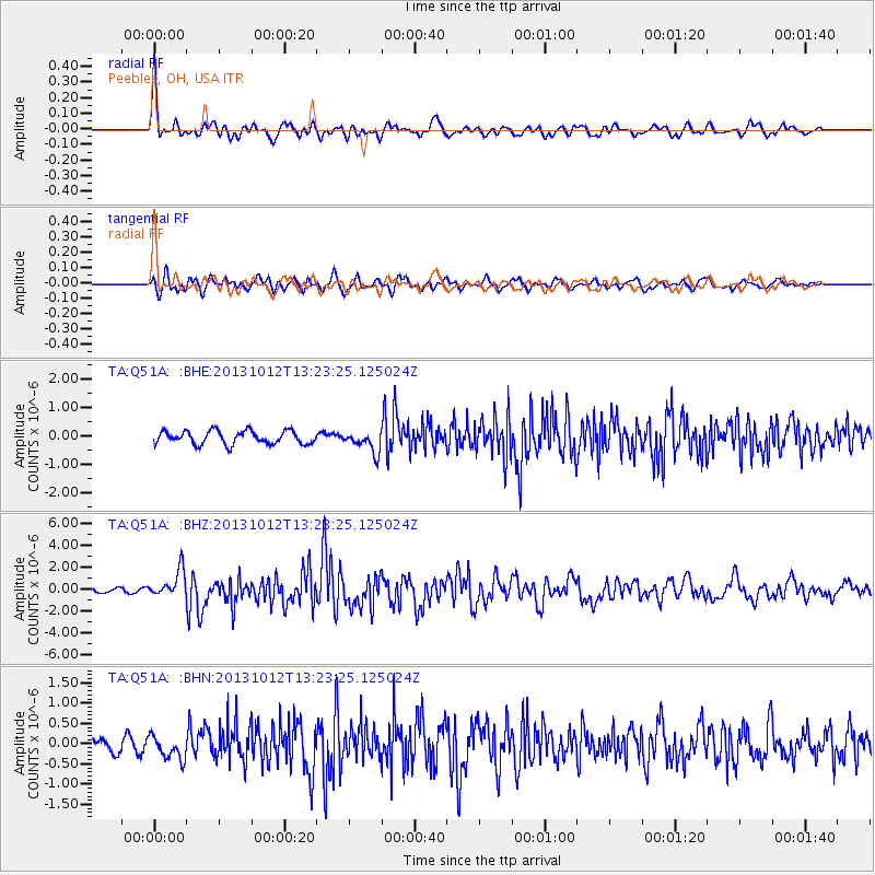
Signal To Noise
| Channel | StoN | STA | LTA |
| TA:Q51A: :BHZ:20131012T13:23:25.125024Z | 4.50652 | 1.2412478E-6 | 2.754338E-7 |
| TA:Q51A: :BHN:20131012T13:23:25.125024Z | 1.3853979 | 2.8940846E-7 | 2.0889917E-7 |
| TA:Q51A: :BHE:20131012T13:23:25.125024Z | 1.6190727 | 3.7617795E-7 | 2.3234162E-7 |
| Arrivals |
| Ps | 3.5 SECOND |
| PpPs | 9.5 SECOND |
| PsPs/PpSs | 13 SECOND |


