You are here: Home > Network List > TA - USArray Transportable Network (new EarthScope stations) Stations List
> Station R58A Rapidan, VA, USA > Earthquake Result Viewer
R58A Rapidan, VA, USA - Earthquake Result Viewer

| Earthquake location: |
Crete, Greece |
| Earthquake latitude/longitude: |
35.5/23.3 |
| Earthquake time(UTC): |
2013/10/12 (285) 13:11:53 GMT |
| Earthquake Depth: |
40 km |
| Earthquake Magnitude: |
6.6 MWW, 6.5 MWB, 6.6 MWW, 6.7 MWC |
| Earthquake Catalog/Contributor: |
NEIC PDE/NEIC COMCAT |
|
| Network: |
TA USArray Transportable Network (new EarthScope stations) |
| Station: |
R58A Rapidan, VA, USA |
| Lat/Lon: |
38.30 N/78.00 W |
| Elevation: |
184 m |
|
| Distance: |
76.6 deg |
| Az: |
307.51 deg |
| Baz: |
55.335 deg |
| Ray Param: |
0.050817113 |
| Estimated Moho Depth: |
32.5 km |
| Estimated Crust Vp/Vs: |
1.65 |
| Assumed Crust Vp: |
6.159 km/s |
| Estimated Crust Vs: |
3.727 km/s |
| Estimated Crust Poisson's Ratio: |
0.21 |
|
| Radial Match: |
84.46202 % |
| Radial Bump: |
400 |
| Transverse Match: |
51.749706 % |
| Transverse Bump: |
400 |
| SOD ConfigId: |
626651 |
| Insert Time: |
2014-04-19 02:39:03.019 +0000 |
| GWidth: |
2.5 |
| Max Bumps: |
400 |
| Tol: |
0.001 |
|
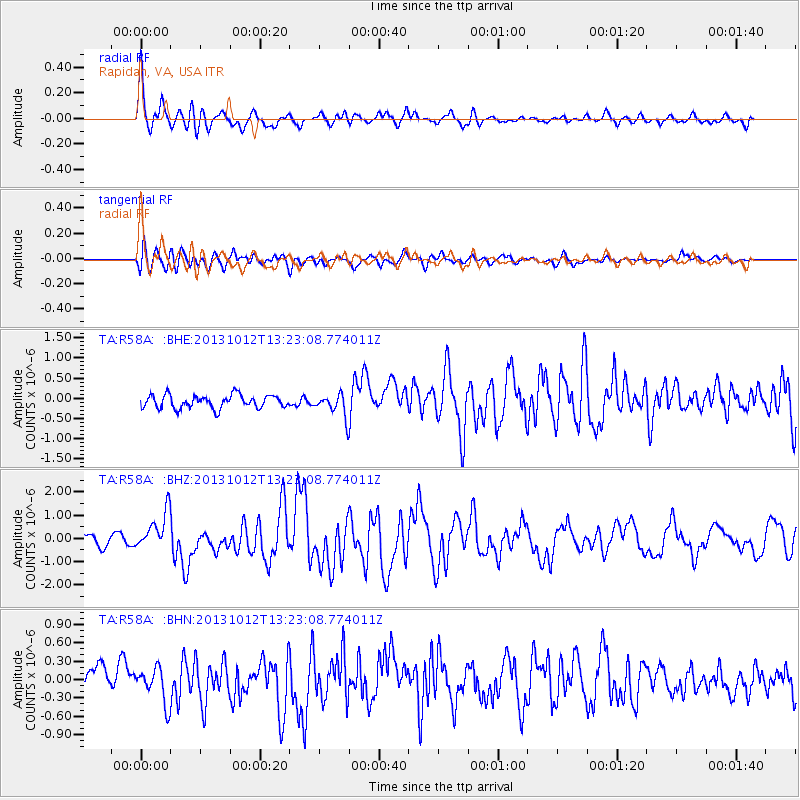
Signal To Noise
| Channel | StoN | STA | LTA |
| TA:R58A: :BHZ:20131012T13:23:08.774011Z | 4.5972214 | 8.2137376E-7 | 1.7866743E-7 |
| TA:R58A: :BHN:20131012T13:23:08.774011Z | 1.6005883 | 2.8805687E-7 | 1.7996936E-7 |
| TA:R58A: :BHE:20131012T13:23:08.774011Z | 1.7024093 | 2.766387E-7 | 1.6249835E-7 |
| Arrivals |
| Ps | 3.6 SECOND |
| PpPs | 14 SECOND |
| PsPs/PpSs | 17 SECOND |


