You are here: Home > Network List > TA - USArray Transportable Network (new EarthScope stations) Stations List
> Station T47A Sharon Grove, KY, USA > Earthquake Result Viewer
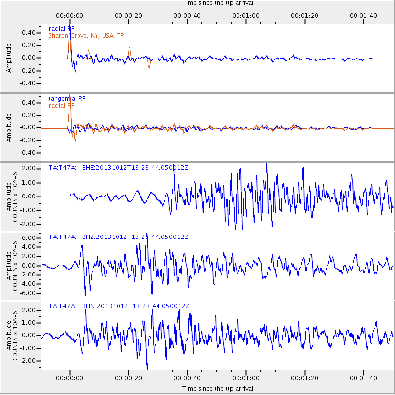
T47A Sharon Grove, KY, USA - Earthquake Result Viewer
| Earthquake location: |
Crete, Greece |
| Earthquake latitude/longitude: |
35.5/23.3 |
| Earthquake time(UTC): |
2013/10/12 (285) 13:11:53 GMT |
| Earthquake Depth: |
40 km |
| Earthquake Magnitude: |
6.6 MWW, 6.5 MWB, 6.6 MWW, 6.7 MWC |
| Earthquake Catalog/Contributor: |
NEIC PDE/NEIC COMCAT |
|
| Network: |
TA USArray Transportable Network (new EarthScope stations) |
| Station: |
T47A Sharon Grove, KY, USA |
| Lat/Lon: |
36.99 N/87.11 W |
| Elevation: |
217 m |
|
| Distance: |
83.2 deg |
| Az: |
310.881 deg |
| Baz: |
50.385 deg |
| Ray Param: |
0.04632964 |
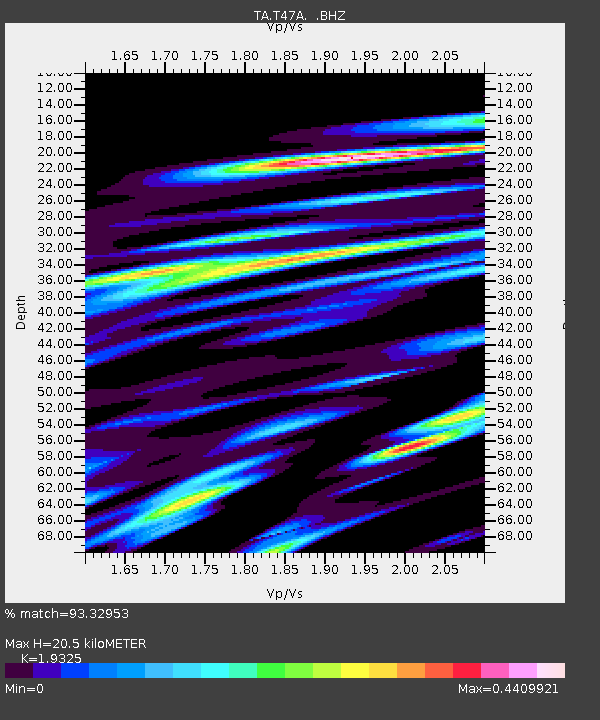
| Estimated Moho Depth: |
20.5 km |
| Estimated Crust Vp/Vs: |
1.93 |
| Assumed Crust Vp: |
6.444 km/s |
| Estimated Crust Vs: |
3.334 km/s |
| Estimated Crust Poisson's Ratio: |
0.32 |
|
| Radial Match: |
93.32953 % |
| Radial Bump: |
302 |
| Transverse Match: |
80.36905 % |
| Transverse Bump: |
400 |
| SOD ConfigId: |
626651 |
| Insert Time: |
2014-04-19 02:39:57.928 +0000 |
| GWidth: |
2.5 |
| Max Bumps: |
400 |
| Tol: |
0.001 |
|
Signal To Noise
| Channel | StoN | STA | LTA |
| TA:T47A: :BHZ:20131012T13:23:44.050012Z | 7.271383 | 1.666518E-6 | 2.291886E-7 |
| TA:T47A: :BHN:20131012T13:23:44.050012Z | 2.5635567 | 4.822061E-7 | 1.8810042E-7 |
| TA:T47A: :BHE:20131012T13:23:44.050012Z | 2.7557356 | 4.7713206E-7 | 1.7314144E-7 |
| Arrivals |
| Ps | 3.0 SECOND |
| PpPs | 9.1 SECOND |
| PsPs/PpSs | 12 SECOND |


