You are here: Home > Network List > TA - USArray Transportable Network (new EarthScope stations) Stations List
> Station W52A Murphy, NC, USA > Earthquake Result Viewer
W52A Murphy, NC, USA - Earthquake Result Viewer
| Earthquake location: |
Crete, Greece |
| Earthquake latitude/longitude: |
35.5/23.3 |
| Earthquake time(UTC): |
2013/10/12 (285) 13:11:53 GMT |
| Earthquake Depth: |
40 km |
| Earthquake Magnitude: |
6.6 MWW, 6.5 MWB, 6.6 MWW, 6.7 MWC |
| Earthquake Catalog/Contributor: |
NEIC PDE/NEIC COMCAT |
|
| Network: |
TA USArray Transportable Network (new EarthScope stations) |
| Station: |
W52A Murphy, NC, USA |
| Lat/Lon: |
35.09 N/83.93 W |
| Elevation: |
519 m |
|
| Distance: |
82.3 deg |
| Az: |
307.768 deg |
| Baz: |
51.854 deg |
| Ray Param: |
0.046898138 |
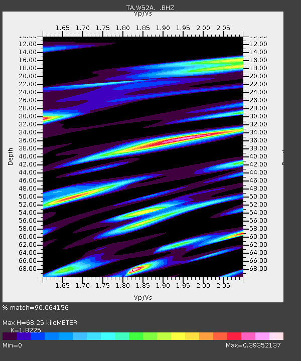
| Estimated Moho Depth: |
68.25 km |
| Estimated Crust Vp/Vs: |
1.82 |
| Assumed Crust Vp: |
6.35 km/s |
| Estimated Crust Vs: |
3.484 km/s |
| Estimated Crust Poisson's Ratio: |
0.28 |
|
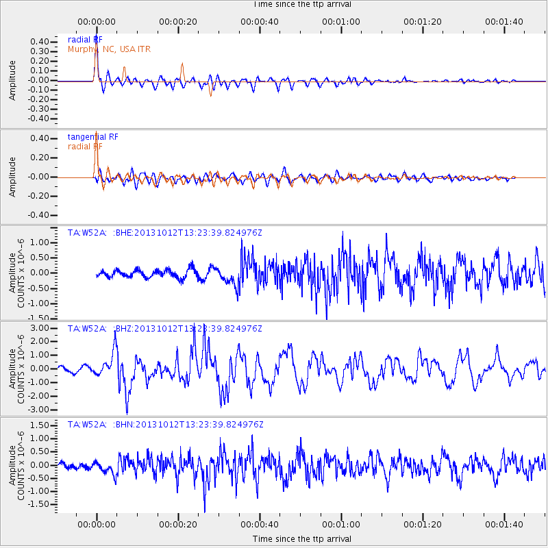
| Radial Match: |
90.064156 % |
| Radial Bump: |
400 |
| Transverse Match: |
78.47169 % |
| Transverse Bump: |
400 |
| SOD ConfigId: |
626651 |
| Insert Time: |
2014-04-19 02:42:10.637 +0000 |
| GWidth: |
2.5 |
| Max Bumps: |
400 |
| Tol: |
0.001 |
|
Signal To Noise
| Channel | StoN | STA | LTA |
| TA:W52A: :BHZ:20131012T13:23:39.824976Z | 5.510874 | 9.477903E-7 | 1.7198549E-7 |
| TA:W52A: :BHN:20131012T13:23:39.824976Z | 2.05712 | 2.3517781E-7 | 1.1432382E-7 |
| TA:W52A: :BHE:20131012T13:23:39.824976Z | 2.375824 | 3.0587185E-7 | 1.287435E-7 |
| Arrivals |
| Ps | 9.1 SECOND |
| PpPs | 30 SECOND |
| PsPs/PpSs | 39 SECOND |


