You are here: Home > Network List > TA - USArray Transportable Network (new EarthScope stations) Stations List
> Station W61A Ground Anchor Farm, New Bern, NC, USA > Earthquake Result Viewer
W61A Ground Anchor Farm, New Bern, NC, USA - Earthquake Result Viewer
| Earthquake location: |
Crete, Greece |
| Earthquake latitude/longitude: |
35.5/23.3 |
| Earthquake time(UTC): |
2013/10/12 (285) 13:11:53 GMT |
| Earthquake Depth: |
40 km |
| Earthquake Magnitude: |
6.6 MWW, 6.5 MWB, 6.6 MWW, 6.7 MWC |
| Earthquake Catalog/Contributor: |
NEIC PDE/NEIC COMCAT |
|
| Network: |
TA USArray Transportable Network (new EarthScope stations) |
| Station: |
W61A Ground Anchor Farm, New Bern, NC, USA |
| Lat/Lon: |
35.18 N/76.99 W |
| Elevation: |
6.0 m |
|
| Distance: |
77.7 deg |
| Az: |
304.408 deg |
| Baz: |
55.249 deg |
| Ray Param: |
0.050072253 |
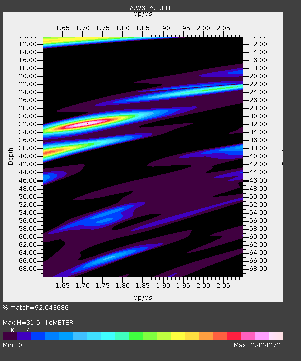
| Estimated Moho Depth: |
31.5 km |
| Estimated Crust Vp/Vs: |
1.71 |
| Assumed Crust Vp: |
6.565 km/s |
| Estimated Crust Vs: |
3.839 km/s |
| Estimated Crust Poisson's Ratio: |
0.24 |
|
| Radial Match: |
92.043686 % |
| Radial Bump: |
400 |
| Transverse Match: |
75.99526 % |
| Transverse Bump: |
400 |
| SOD ConfigId: |
626651 |
| Insert Time: |
2014-04-19 02:42:28.290 +0000 |
| GWidth: |
2.5 |
| Max Bumps: |
400 |
| Tol: |
0.001 |
|
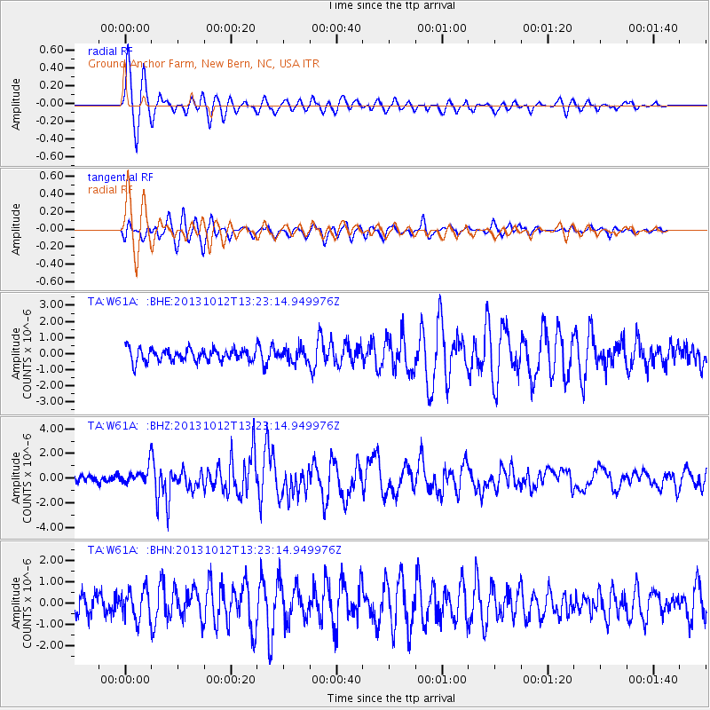
Signal To Noise
| Channel | StoN | STA | LTA |
| TA:W61A: :BHZ:20131012T13:23:14.949976Z | 3.042373 | 7.21634E-7 | 2.3719447E-7 |
| TA:W61A: :BHN:20131012T13:23:14.949976Z | 1.7176389 | 6.9117186E-7 | 4.023965E-7 |
| TA:W61A: :BHE:20131012T13:23:14.949976Z | 1.0805404 | 4.14797E-7 | 3.838792E-7 |
| Arrivals |
| Ps | 3.5 SECOND |
| PpPs | 13 SECOND |
| PsPs/PpSs | 16 SECOND |


