You are here: Home > Network List > TA - USArray Transportable Network (new EarthScope stations) Stations List
> Station W60A Pink Hill, NC, USA > Earthquake Result Viewer
W60A Pink Hill, NC, USA - Earthquake Result Viewer
| Earthquake location: |
Crete, Greece |
| Earthquake latitude/longitude: |
35.5/23.3 |
| Earthquake time(UTC): |
2013/10/12 (285) 13:11:53 GMT |
| Earthquake Depth: |
40 km |
| Earthquake Magnitude: |
6.6 MWW, 6.5 MWB, 6.6 MWW, 6.7 MWC |
| Earthquake Catalog/Contributor: |
NEIC PDE/NEIC COMCAT |
|
| Network: |
TA USArray Transportable Network (new EarthScope stations) |
| Station: |
W60A Pink Hill, NC, USA |
| Lat/Lon: |
35.05 N/77.71 W |
| Elevation: |
30 m |
|
| Distance: |
78.3 deg |
| Az: |
304.65 deg |
| Baz: |
54.885 deg |
| Ray Param: |
0.04969363 |
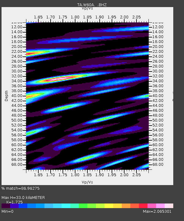
| Estimated Moho Depth: |
33.0 km |
| Estimated Crust Vp/Vs: |
1.73 |
| Assumed Crust Vp: |
6.565 km/s |
| Estimated Crust Vs: |
3.806 km/s |
| Estimated Crust Poisson's Ratio: |
0.25 |
|
| Radial Match: |
86.96275 % |
| Radial Bump: |
400 |
| Transverse Match: |
78.643845 % |
| Transverse Bump: |
400 |
| SOD ConfigId: |
626651 |
| Insert Time: |
2014-04-19 02:42:29.031 +0000 |
| GWidth: |
2.5 |
| Max Bumps: |
400 |
| Tol: |
0.001 |
|

Signal To Noise
| Channel | StoN | STA | LTA |
| TA:W60A: :BHZ:20131012T13:23:18.024988Z | 4.474682 | 7.649235E-7 | 1.7094479E-7 |
| TA:W60A: :BHN:20131012T13:23:18.024988Z | 0.9808362 | 2.4509998E-7 | 2.498888E-7 |
| TA:W60A: :BHE:20131012T13:23:18.024988Z | 1.1295642 | 2.4897525E-7 | 2.2041709E-7 |
| Arrivals |
| Ps | 3.8 SECOND |
| PpPs | 13 SECOND |
| PsPs/PpSs | 17 SECOND |


