You are here: Home > Network List > TA - USArray Transportable Network (new EarthScope stations) Stations List
> Station X43A Marvell, AR, USA > Earthquake Result Viewer
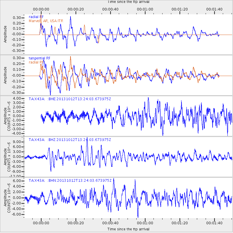
X43A Marvell, AR, USA - Earthquake Result Viewer
*The percent match for this event was below the threshold and hence no stack was calculated.
| Earthquake location: |
Crete, Greece |
| Earthquake latitude/longitude: |
35.5/23.3 |
| Earthquake time(UTC): |
2013/10/12 (285) 13:11:53 GMT |
| Earthquake Depth: |
40 km |
| Earthquake Magnitude: |
6.6 MWW, 6.5 MWB, 6.6 MWW, 6.7 MWC |
| Earthquake Catalog/Contributor: |
NEIC PDE/NEIC COMCAT |
|
| Network: |
TA USArray Transportable Network (new EarthScope stations) |
| Station: |
X43A Marvell, AR, USA |
| Lat/Lon: |
34.52 N/90.88 W |
| Elevation: |
53 m |
|
| Distance: |
87.1 deg |
| Az: |
311.016 deg |
| Baz: |
48.199 deg |
| Ray Param: |
$rayparam |
*The percent match for this event was below the threshold and hence was not used in the summary stack. |
|
| Radial Match: |
61.289017 % |
| Radial Bump: |
400 |
| Transverse Match: |
85.201645 % |
| Transverse Bump: |
400 |
| SOD ConfigId: |
626651 |
| Insert Time: |
2014-04-19 02:42:41.266 +0000 |
| GWidth: |
2.5 |
| Max Bumps: |
400 |
| Tol: |
0.001 |
|
Signal To Noise
| Channel | StoN | STA | LTA |
| TA:X43A: :BHZ:20131012T13:24:03.673975Z | 5.2671714 | 2.0220498E-6 | 3.8389672E-7 |
| TA:X43A: :BHN:20131012T13:24:03.673975Z | 1.3942256 | 1.2455997E-6 | 8.93399E-7 |
| TA:X43A: :BHE:20131012T13:24:03.673975Z | 1.4193441 | 9.201652E-7 | 6.483031E-7 |
| Arrivals |
| Ps | |
| PpPs | |
| PsPs/PpSs | |


