You are here: Home > Network List > II - Global Seismograph Network (GSN - IRIS/IDA) Stations List
> Station TLY Talaya, Russia > Earthquake Result Viewer
TLY Talaya, Russia - Earthquake Result Viewer

| Earthquake location: |
Vanuatu Islands |
| Earthquake latitude/longitude: |
-19.3/168.9 |
| Earthquake time(UTC): |
1992/10/11 (285) 19:24:29 GMT |
| Earthquake Depth: |
157 km |
| Earthquake Magnitude: |
6.4 MB |
| Earthquake Catalog/Contributor: |
WHDF/NEIC |
|
| Network: |
II Global Seismograph Network (GSN - IRIS/IDA) |
| Station: |
TLY Talaya, Russia |
| Lat/Lon: |
51.68 N/103.64 E |
| Elevation: |
579 m |
|
| Distance: |
90.6 deg |
| Az: |
325.561 deg |
| Baz: |
120.903 deg |
| Ray Param: |
0.04162759 |
| Estimated Moho Depth: |
12.25 km |
| Estimated Crust Vp/Vs: |
2.05 |
| Assumed Crust Vp: |
6.419 km/s |
| Estimated Crust Vs: |
3.135 km/s |
| Estimated Crust Poisson's Ratio: |
0.34 |
|
| Radial Match: |
98.713974 % |
| Radial Bump: |
398 |
| Transverse Match: |
95.246735 % |
| Transverse Bump: |
400 |
| SOD ConfigId: |
61242 |
| Insert Time: |
2010-03-01 17:21:00.576 +0000 |
| GWidth: |
2.5 |
| Max Bumps: |
400 |
| Tol: |
0.001 |
|
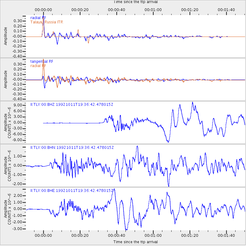
Signal To Noise
| Channel | StoN | STA | LTA |
| II:TLY:00:BHN:19921011T19:36:42.478015Z | 4.1500454 | 1.4849756E-7 | 3.578215E-8 |
| II:TLY:00:BHE:19921011T19:36:42.478015Z | 5.2078896 | 2.746637E-7 | 5.2739924E-8 |
| II:TLY:00:BHZ:19921011T19:36:42.478015Z | 18.666224 | 9.250712E-7 | 4.9558565E-8 |
| Arrivals |
| Ps | 2.0 SECOND |
| PpPs | 5.7 SECOND |
| PsPs/PpSs | 7.7 SECOND |


