You are here: Home > Network List > TA - USArray Transportable Network (new EarthScope stations) Stations List
> Station Y59A Loris, SC, USA > Earthquake Result Viewer
Y59A Loris, SC, USA - Earthquake Result Viewer

| Earthquake location: |
Crete, Greece |
| Earthquake latitude/longitude: |
35.5/23.3 |
| Earthquake time(UTC): |
2013/10/12 (285) 13:11:53 GMT |
| Earthquake Depth: |
40 km |
| Earthquake Magnitude: |
6.6 MWW, 6.5 MWB, 6.6 MWW, 6.7 MWC |
| Earthquake Catalog/Contributor: |
NEIC PDE/NEIC COMCAT |
|
| Network: |
TA USArray Transportable Network (new EarthScope stations) |
| Station: |
Y59A Loris, SC, USA |
| Lat/Lon: |
33.99 N/78.87 W |
| Elevation: |
2.0 m |
|
| Distance: |
79.7 deg |
| Az: |
304.337 deg |
| Baz: |
54.171 deg |
| Ray Param: |
0.048743386 |
| Estimated Moho Depth: |
30.25 km |
| Estimated Crust Vp/Vs: |
1.60 |
| Assumed Crust Vp: |
6.24 km/s |
| Estimated Crust Vs: |
3.9 km/s |
| Estimated Crust Poisson's Ratio: |
0.18 |
|
| Radial Match: |
92.42467 % |
| Radial Bump: |
372 |
| Transverse Match: |
75.32516 % |
| Transverse Bump: |
400 |
| SOD ConfigId: |
626651 |
| Insert Time: |
2014-04-19 02:43:33.470 +0000 |
| GWidth: |
2.5 |
| Max Bumps: |
400 |
| Tol: |
0.001 |
|
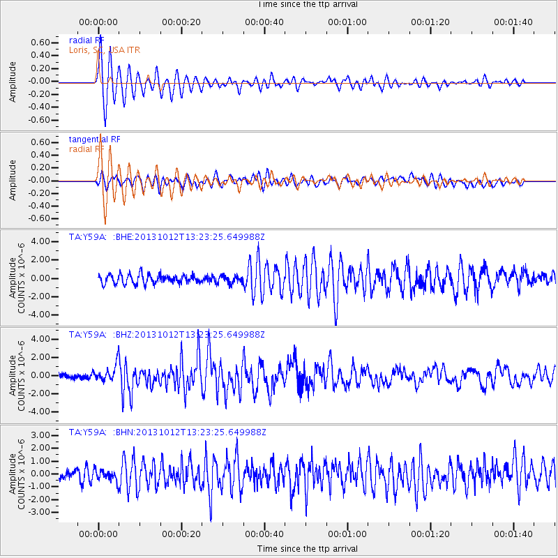
Signal To Noise
| Channel | StoN | STA | LTA |
| TA:Y59A: :BHZ:20131012T13:23:25.649988Z | 4.48511 | 9.585776E-7 | 2.1372445E-7 |
| TA:Y59A: :BHN:20131012T13:23:25.649988Z | 1.1627415 | 4.3943155E-7 | 3.779271E-7 |
| TA:Y59A: :BHE:20131012T13:23:25.649988Z | 0.8106123 | 3.9778797E-7 | 4.9072526E-7 |
| Arrivals |
| Ps | 3.0 SECOND |
| PpPs | 12 SECOND |
| PsPs/PpSs | 15 SECOND |


