You are here: Home > Network List > TA - USArray Transportable Network (new EarthScope stations) Stations List
> Station Z51A Franklin, GA, USA > Earthquake Result Viewer
Z51A Franklin, GA, USA - Earthquake Result Viewer
| Earthquake location: |
Crete, Greece |
| Earthquake latitude/longitude: |
35.5/23.3 |
| Earthquake time(UTC): |
2013/10/12 (285) 13:11:53 GMT |
| Earthquake Depth: |
40 km |
| Earthquake Magnitude: |
6.6 MWW, 6.5 MWB, 6.6 MWW, 6.7 MWC |
| Earthquake Catalog/Contributor: |
NEIC PDE/NEIC COMCAT |
|
| Network: |
TA USArray Transportable Network (new EarthScope stations) |
| Station: |
Z51A Franklin, GA, USA |
| Lat/Lon: |
33.32 N/85.17 W |
| Elevation: |
249 m |
|
| Distance: |
84.2 deg |
| Az: |
307.02 deg |
| Baz: |
51.069 deg |
| Ray Param: |
0.045559242 |
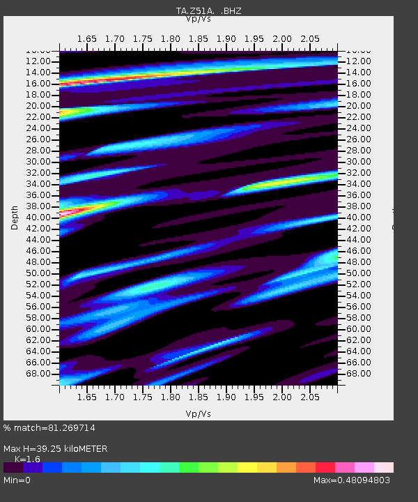
| Estimated Moho Depth: |
39.25 km |
| Estimated Crust Vp/Vs: |
1.60 |
| Assumed Crust Vp: |
6.719 km/s |
| Estimated Crust Vs: |
4.2 km/s |
| Estimated Crust Poisson's Ratio: |
0.18 |
|
| Radial Match: |
81.269714 % |
| Radial Bump: |
383 |
| Transverse Match: |
72.75718 % |
| Transverse Bump: |
400 |
| SOD ConfigId: |
626651 |
| Insert Time: |
2014-04-19 02:43:42.462 +0000 |
| GWidth: |
2.5 |
| Max Bumps: |
400 |
| Tol: |
0.001 |
|

Signal To Noise
| Channel | StoN | STA | LTA |
| TA:Z51A: :BHZ:20131012T13:23:49.623987Z | 5.2036977 | 7.92118E-7 | 1.5222214E-7 |
| TA:Z51A: :BHN:20131012T13:23:49.623987Z | 1.9332083 | 2.4551534E-7 | 1.269989E-7 |
| TA:Z51A: :BHE:20131012T13:23:49.623987Z | 2.0193183 | 3.0517782E-7 | 1.5112913E-7 |
| Arrivals |
| Ps | 3.6 SECOND |
| PpPs | 15 SECOND |
| PsPs/PpSs | 18 SECOND |


