You are here: Home > Network List > TA - USArray Transportable Network (new EarthScope stations) Stations List
> Station G59A Clarenceville, QC, USA > Earthquake Result Viewer
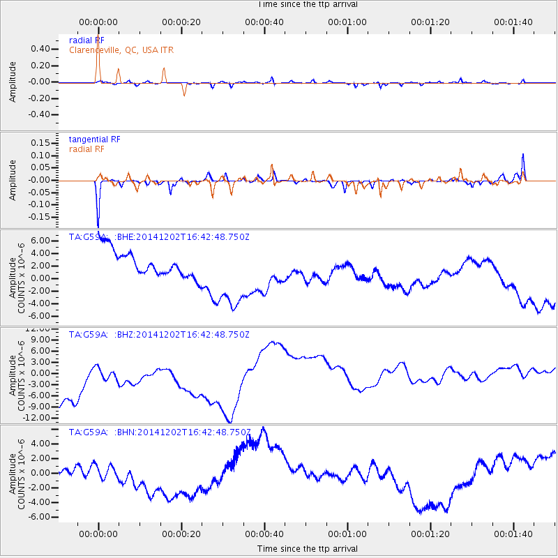
G59A Clarenceville, QC, USA - Earthquake Result Viewer
*The percent match for this event was below the threshold and hence no stack was calculated.
| Earthquake location: |
Fox Islands, Aleutian Islands |
| Earthquake latitude/longitude: |
51.6/-171.2 |
| Earthquake time(UTC): |
2014/12/02 (336) 16:33:14 GMT |
| Earthquake Depth: |
53 km |
| Earthquake Magnitude: |
5.2 MW, 5.1 mb, 4.6 ML |
| Earthquake Catalog/Contributor: |
ISC/ISC |
|
| Network: |
TA USArray Transportable Network (new EarthScope stations) |
| Station: |
G59A Clarenceville, QC, USA |
| Lat/Lon: |
45.08 N/73.18 W |
| Elevation: |
36 m |
|
| Distance: |
60.6 deg |
| Az: |
53.606 deg |
| Baz: |
314.922 deg |
| Ray Param: |
$rayparam |
*The percent match for this event was below the threshold and hence was not used in the summary stack. |
|
| Radial Match: |
50.46738 % |
| Radial Bump: |
272 |
| Transverse Match: |
69.687485 % |
| Transverse Bump: |
183 |
| SOD ConfigId: |
3390531 |
| Insert Time: |
2019-04-15 07:37:40.975 +0000 |
| GWidth: |
2.5 |
| Max Bumps: |
400 |
| Tol: |
0.001 |
|
Signal To Noise
| Channel | StoN | STA | LTA |
| TA:G59A: :BHZ:20141202T16:42:48.750Z | 0.5431888 | 1.2390279E-5 | 2.2810262E-5 |
| TA:G59A: :BHN:20141202T16:42:48.750Z | 1.0380926 | 1.5169294E-6 | 1.4612658E-6 |
| TA:G59A: :BHE:20141202T16:42:48.750Z | 2.827475 | 5.9275E-6 | 2.0963935E-6 |
| Arrivals |
| Ps | |
| PpPs | |
| PsPs/PpSs | |


