You are here: Home > Network List > TA - USArray Transportable Network (new EarthScope stations) Stations List
> Station T56A Rocky Mt, VA, USA > Earthquake Result Viewer
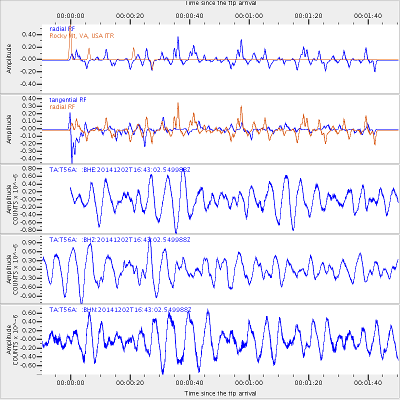
T56A Rocky Mt, VA, USA - Earthquake Result Viewer
*The percent match for this event was below the threshold and hence no stack was calculated.
| Earthquake location: |
Fox Islands, Aleutian Islands |
| Earthquake latitude/longitude: |
51.6/-171.2 |
| Earthquake time(UTC): |
2014/12/02 (336) 16:33:14 GMT |
| Earthquake Depth: |
53 km |
| Earthquake Magnitude: |
5.2 MW, 5.1 mb, 4.6 ML |
| Earthquake Catalog/Contributor: |
ISC/ISC |
|
| Network: |
TA USArray Transportable Network (new EarthScope stations) |
| Station: |
T56A Rocky Mt, VA, USA |
| Lat/Lon: |
37.03 N/80.03 W |
| Elevation: |
387 m |
|
| Distance: |
62.7 deg |
| Az: |
64.218 deg |
| Baz: |
315.474 deg |
| Ray Param: |
$rayparam |
*The percent match for this event was below the threshold and hence was not used in the summary stack. |
|
| Radial Match: |
69.57327 % |
| Radial Bump: |
369 |
| Transverse Match: |
75.27424 % |
| Transverse Bump: |
400 |
| SOD ConfigId: |
3390531 |
| Insert Time: |
2019-04-15 07:38:08.944 +0000 |
| GWidth: |
2.5 |
| Max Bumps: |
400 |
| Tol: |
0.001 |
|
Signal To Noise
| Channel | StoN | STA | LTA |
| TA:T56A: :BHZ:20141202T16:43:02.549988Z | 2.1953638 | 6.3151214E-7 | 2.8765717E-7 |
| TA:T56A: :BHN:20141202T16:43:02.549988Z | 1.1053423 | 2.1088691E-7 | 1.9078878E-7 |
| TA:T56A: :BHE:20141202T16:43:02.549988Z | 1.7028602 | 4.0670014E-7 | 2.3883354E-7 |
| Arrivals |
| Ps | |
| PpPs | |
| PsPs/PpSs | |


