You are here: Home > Network List > US - United States National Seismic Network Stations List
> Station COWI Conover, Wisconsin, USA > Earthquake Result Viewer
COWI Conover, Wisconsin, USA - Earthquake Result Viewer

| Earthquake location: |
Crete, Greece |
| Earthquake latitude/longitude: |
35.5/23.3 |
| Earthquake time(UTC): |
2013/10/12 (285) 13:11:53 GMT |
| Earthquake Depth: |
40 km |
| Earthquake Magnitude: |
6.6 MWW, 6.5 MWB, 6.6 MWW, 6.7 MWC |
| Earthquake Catalog/Contributor: |
NEIC PDE/NEIC COMCAT |
|
| Network: |
US United States National Seismic Network |
| Station: |
COWI Conover, Wisconsin, USA |
| Lat/Lon: |
46.10 N/89.14 W |
| Elevation: |
523 m |
|
| Distance: |
78.5 deg |
| Az: |
318.966 deg |
| Baz: |
50.33 deg |
| Ray Param: |
0.049527004 |
| Estimated Moho Depth: |
39.75 km |
| Estimated Crust Vp/Vs: |
1.77 |
| Assumed Crust Vp: |
6.467 km/s |
| Estimated Crust Vs: |
3.648 km/s |
| Estimated Crust Poisson's Ratio: |
0.27 |
|
| Radial Match: |
91.62623 % |
| Radial Bump: |
340 |
| Transverse Match: |
76.796135 % |
| Transverse Bump: |
400 |
| SOD ConfigId: |
626651 |
| Insert Time: |
2014-04-19 02:45:13.948 +0000 |
| GWidth: |
2.5 |
| Max Bumps: |
400 |
| Tol: |
0.001 |
|
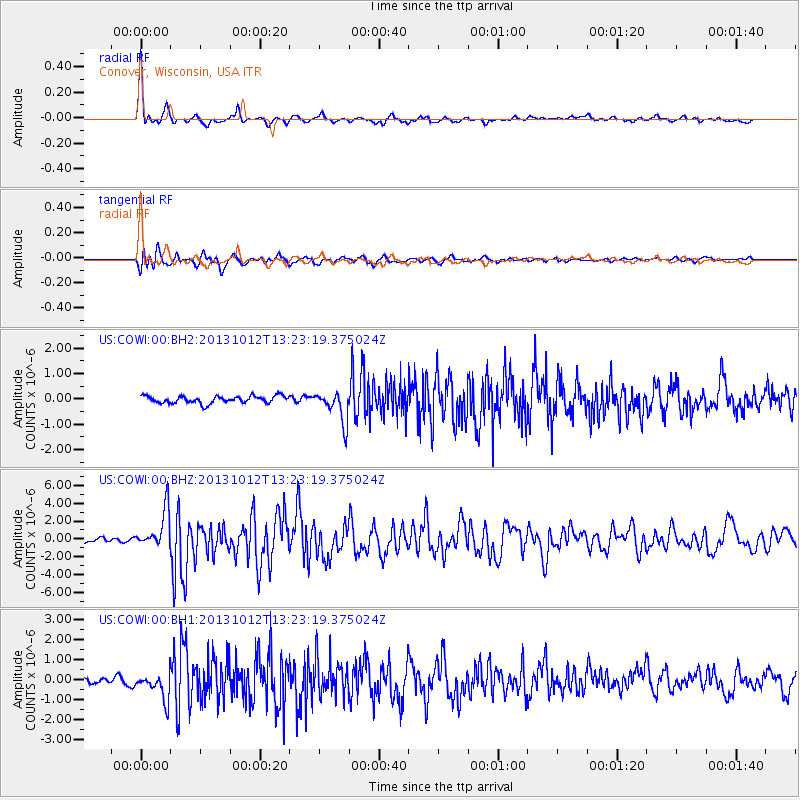
Signal To Noise
| Channel | StoN | STA | LTA |
| US:COWI:00:BHZ:20131012T13:23:19.375024Z | 9.809064 | 2.137984E-6 | 2.1796006E-7 |
| US:COWI:00:BH1:20131012T13:23:19.375024Z | 5.35264 | 6.88981E-7 | 1.2871797E-7 |
| US:COWI:00:BH2:20131012T13:23:19.375024Z | 4.3143 | 6.12955E-7 | 1.4207518E-7 |
| Arrivals |
| Ps | 4.9 SECOND |
| PpPs | 17 SECOND |
| PsPs/PpSs | 21 SECOND |


