You are here: Home > Network List > US - United States National Seismic Network Stations List
> Station LAO LASA Array, Montana, USA > Earthquake Result Viewer
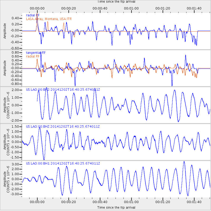
LAO LASA Array, Montana, USA - Earthquake Result Viewer
*The percent match for this event was below the threshold and hence no stack was calculated.
| Earthquake location: |
Fox Islands, Aleutian Islands |
| Earthquake latitude/longitude: |
51.6/-171.2 |
| Earthquake time(UTC): |
2014/12/02 (336) 16:33:14 GMT |
| Earthquake Depth: |
53 km |
| Earthquake Magnitude: |
5.2 MW, 5.1 mb, 4.6 ML |
| Earthquake Catalog/Contributor: |
ISC/ISC |
|
| Network: |
US United States National Seismic Network |
| Station: |
LAO LASA Array, Montana, USA |
| Lat/Lon: |
46.69 N/106.22 W |
| Elevation: |
902 m |
|
| Distance: |
41.5 deg |
| Az: |
70.221 deg |
| Baz: |
301.582 deg |
| Ray Param: |
$rayparam |
*The percent match for this event was below the threshold and hence was not used in the summary stack. |
|
| Radial Match: |
60.043175 % |
| Radial Bump: |
375 |
| Transverse Match: |
46.112324 % |
| Transverse Bump: |
241 |
| SOD ConfigId: |
3390531 |
| Insert Time: |
2019-04-15 07:39:08.989 +0000 |
| GWidth: |
2.5 |
| Max Bumps: |
400 |
| Tol: |
0.001 |
|
Signal To Noise
| Channel | StoN | STA | LTA |
| US:LAO:00:BHZ:20141202T16:40:25.674011Z | 4.3955665 | 1.0691308E-6 | 2.4322935E-7 |
| US:LAO:00:BH1:20141202T16:40:25.674011Z | 0.3152661 | 5.009434E-7 | 1.5889541E-6 |
| US:LAO:00:BH2:20141202T16:40:25.674011Z | 0.80167943 | 9.548924E-7 | 1.1911148E-6 |
| Arrivals |
| Ps | |
| PpPs | |
| PsPs/PpSs | |


