You are here: Home > Network List > GT - Global Telemetered Seismograph Network (USAF/USGS) Stations List
> Station PLCA Paso Flores, Argentina > Earthquake Result Viewer
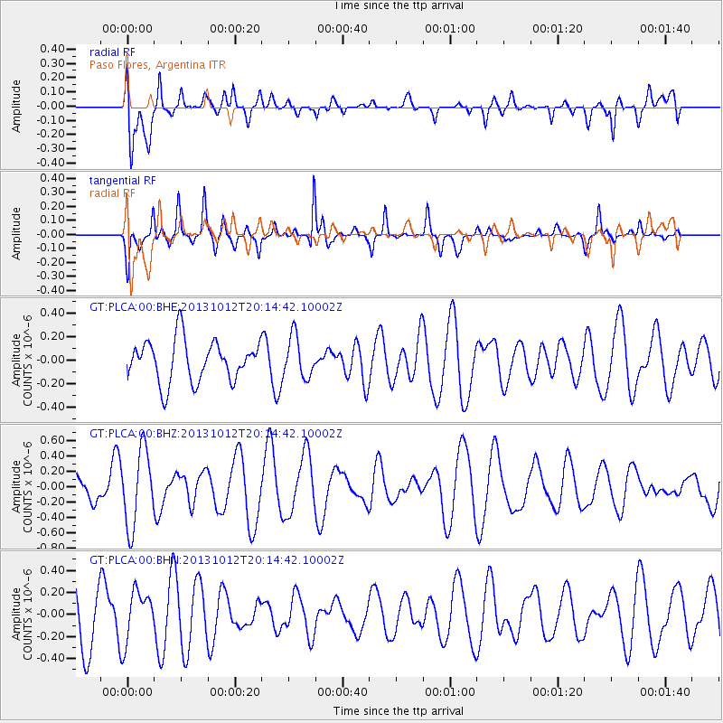
PLCA Paso Flores, Argentina - Earthquake Result Viewer
*The percent match for this event was below the threshold and hence no stack was calculated.
| Earthquake location: |
Mid-Indian Ridge |
| Earthquake latitude/longitude: |
-36.7/78.7 |
| Earthquake time(UTC): |
2013/10/12 (285) 20:01:37 GMT |
| Earthquake Depth: |
4.4 km |
| Earthquake Magnitude: |
5.5 MWB, 5.6 MWC |
| Earthquake Catalog/Contributor: |
NEIC PDE/NEIC COMCAT |
|
| Network: |
GT Global Telemetered Seismograph Network (USAF/USGS) |
| Station: |
PLCA Paso Flores, Argentina |
| Lat/Lon: |
40.73 S/70.55 W |
| Elevation: |
1050 m |
|
| Distance: |
97.9 deg |
| Az: |
203.083 deg |
| Baz: |
155.516 deg |
| Ray Param: |
$rayparam |
*The percent match for this event was below the threshold and hence was not used in the summary stack. |
|
| Radial Match: |
49.2375 % |
| Radial Bump: |
400 |
| Transverse Match: |
76.02422 % |
| Transverse Bump: |
353 |
| SOD ConfigId: |
626651 |
| Insert Time: |
2014-04-19 03:00:32.236 +0000 |
| GWidth: |
2.5 |
| Max Bumps: |
400 |
| Tol: |
0.001 |
|
Signal To Noise
| Channel | StoN | STA | LTA |
| GT:PLCA:00:BHZ:20131012T20:14:42.10002Z | 3.661118 | 4.978698E-7 | 1.3598844E-7 |
| GT:PLCA:00:BHN:20131012T20:14:42.10002Z | 0.86729175 | 2.2631207E-7 | 2.609411E-7 |
| GT:PLCA:00:BHE:20131012T20:14:42.10002Z | 0.99792504 | 1.7658324E-7 | 1.7695041E-7 |
| Arrivals |
| Ps | |
| PpPs | |
| PsPs/PpSs | |


