You are here: Home > Network List > II - Global Seismograph Network (GSN - IRIS/IDA) Stations List
> Station TLY Talaya, Russia > Earthquake Result Viewer
TLY Talaya, Russia - Earthquake Result Viewer
| Earthquake location: |
Santa Cruz Islands |
| Earthquake latitude/longitude: |
-12.0/166.5 |
| Earthquake time(UTC): |
1992/08/04 (217) 21:08:44 GMT |
| Earthquake Depth: |
109 km |
| Earthquake Magnitude: |
5.9 MB |
| Earthquake Catalog/Contributor: |
WHDF/NEIC |
|
| Network: |
II Global Seismograph Network (GSN - IRIS/IDA) |
| Station: |
TLY Talaya, Russia |
| Lat/Lon: |
51.68 N/103.64 E |
| Elevation: |
579 m |
|
| Distance: |
83.3 deg |
| Az: |
326.098 deg |
| Baz: |
118.779 deg |
| Ray Param: |
0.046016123 |
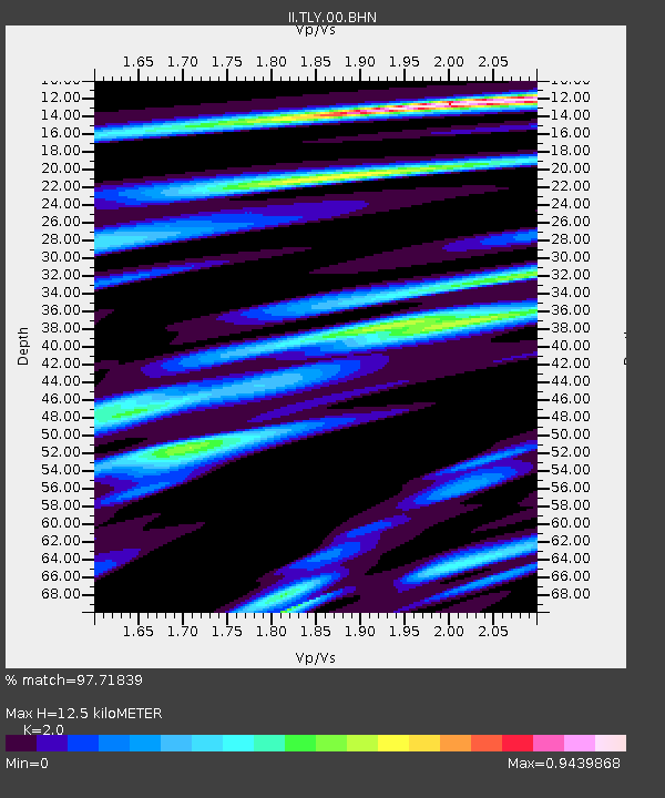
| Estimated Moho Depth: |
12.5 km |
| Estimated Crust Vp/Vs: |
2.00 |
| Assumed Crust Vp: |
6.419 km/s |
| Estimated Crust Vs: |
3.21 km/s |
| Estimated Crust Poisson's Ratio: |
0.33 |
|
| Radial Match: |
97.71839 % |
| Radial Bump: |
400 |
| Transverse Match: |
95.20666 % |
| Transverse Bump: |
400 |
| SOD ConfigId: |
17000 |
| Insert Time: |
2010-03-01 17:21:55.340 +0000 |
| GWidth: |
2.5 |
| Max Bumps: |
400 |
| Tol: |
0.001 |
|

Signal To Noise
| Channel | StoN | STA | LTA |
| II:TLY:00:BHN:19920804T21:20:27.752014Z | 6.4963307 | 1.5410814E-7 | 2.3722336E-8 |
| II:TLY:00:BHE:19920804T21:20:27.752014Z | 10.6631975 | 2.843348E-7 | 2.666506E-8 |
| II:TLY:00:BHZ:19920804T21:20:27.752014Z | 35.369534 | 9.607197E-7 | 2.7162354E-8 |
| Arrivals |
| Ps | 2.0 SECOND |
| PpPs | 5.7 SECOND |
| PsPs/PpSs | 7.7 SECOND |


