You are here: Home > Network List > G - GEOSCOPE Stations List
> Station INU Inuyama, Japan > Earthquake Result Viewer
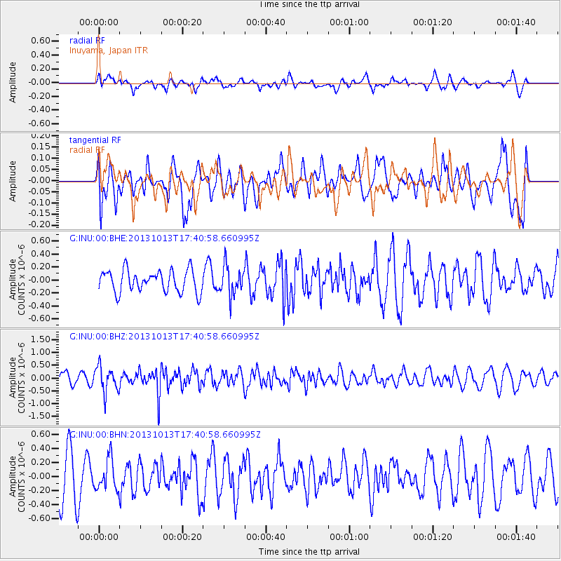
INU Inuyama, Japan - Earthquake Result Viewer
*The percent match for this event was below the threshold and hence no stack was calculated.
| Earthquake location: |
Off W Coast Of Northern Sumatra |
| Earthquake latitude/longitude: |
4.0/95.9 |
| Earthquake time(UTC): |
2013/10/13 (286) 17:32:45 GMT |
| Earthquake Depth: |
46 km |
| Earthquake Magnitude: |
5.6 MWB, 5.6 MWC |
| Earthquake Catalog/Contributor: |
NEIC PDE/NEIC COMCAT |
|
| Network: |
G GEOSCOPE |
| Station: |
INU Inuyama, Japan |
| Lat/Lon: |
35.35 N/137.03 E |
| Elevation: |
132 m |
|
| Distance: |
49.2 deg |
| Az: |
45.306 deg |
| Baz: |
240.176 deg |
| Ray Param: |
$rayparam |
*The percent match for this event was below the threshold and hence was not used in the summary stack. |
|
| Radial Match: |
45.30666 % |
| Radial Bump: |
400 |
| Transverse Match: |
38.022354 % |
| Transverse Bump: |
400 |
| SOD ConfigId: |
626651 |
| Insert Time: |
2014-04-19 03:07:49.495 +0000 |
| GWidth: |
2.5 |
| Max Bumps: |
400 |
| Tol: |
0.001 |
|
Signal To Noise
| Channel | StoN | STA | LTA |
| G:INU:00:BHZ:20131013T17:40:58.660995Z | 1.6480039 | 5.107782E-7 | 3.0993752E-7 |
| G:INU:00:BHN:20131013T17:40:58.660995Z | 0.61313224 | 2.252916E-7 | 3.6744373E-7 |
| G:INU:00:BHE:20131013T17:40:58.660995Z | 1.3618956 | 2.3020138E-7 | 1.6903013E-7 |
| Arrivals |
| Ps | |
| PpPs | |
| PsPs/PpSs | |


