You are here: Home > Network List > IU - Global Seismograph Network (GSN - IRIS/USGS) Stations List
> Station MAJO Matsushiro, Japan > Earthquake Result Viewer
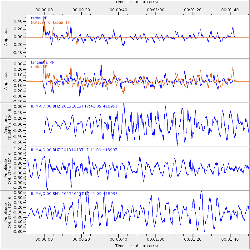
MAJO Matsushiro, Japan - Earthquake Result Viewer
*The percent match for this event was below the threshold and hence no stack was calculated.
| Earthquake location: |
Off W Coast Of Northern Sumatra |
| Earthquake latitude/longitude: |
4.0/95.9 |
| Earthquake time(UTC): |
2013/10/13 (286) 17:32:45 GMT |
| Earthquake Depth: |
46 km |
| Earthquake Magnitude: |
5.6 MWB, 5.6 MWC |
| Earthquake Catalog/Contributor: |
NEIC PDE/NEIC COMCAT |
|
| Network: |
IU Global Seismograph Network (GSN - IRIS/USGS) |
| Station: |
MAJO Matsushiro, Japan |
| Lat/Lon: |
36.55 N/138.20 E |
| Elevation: |
405 m |
|
| Distance: |
50.6 deg |
| Az: |
44.569 deg |
| Baz: |
240.388 deg |
| Ray Param: |
$rayparam |
*The percent match for this event was below the threshold and hence was not used in the summary stack. |
|
| Radial Match: |
59.081535 % |
| Radial Bump: |
400 |
| Transverse Match: |
63.87557 % |
| Transverse Bump: |
400 |
| SOD ConfigId: |
626651 |
| Insert Time: |
2014-04-19 03:10:46.229 +0000 |
| GWidth: |
2.5 |
| Max Bumps: |
400 |
| Tol: |
0.001 |
|
Signal To Noise
| Channel | StoN | STA | LTA |
| IU:MAJO:00:BHZ:20131013T17:41:09.41899Z | 2.6133442 | 6.300888E-7 | 2.411044E-7 |
| IU:MAJO:00:BH1:20131013T17:41:09.41899Z | 0.9858624 | 1.7925093E-7 | 1.8182146E-7 |
| IU:MAJO:00:BH2:20131013T17:41:09.41899Z | 1.4279052 | 2.2482236E-7 | 1.5744908E-7 |
| Arrivals |
| Ps | |
| PpPs | |
| PsPs/PpSs | |


