You are here: Home > Network List > TJ - Tajikistan National Seismic Network Stations List
> Station GARM Garm, Tajikistan > Earthquake Result Viewer
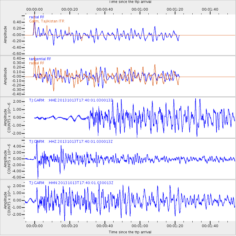
GARM Garm, Tajikistan - Earthquake Result Viewer
*The percent match for this event was below the threshold and hence no stack was calculated.
| Earthquake location: |
Off W Coast Of Northern Sumatra |
| Earthquake latitude/longitude: |
4.0/95.9 |
| Earthquake time(UTC): |
2013/10/13 (286) 17:32:45 GMT |
| Earthquake Depth: |
46 km |
| Earthquake Magnitude: |
5.6 MWB, 5.6 MWC |
| Earthquake Catalog/Contributor: |
NEIC PDE/NEIC COMCAT |
|
| Network: |
TJ Tajikistan National Seismic Network |
| Station: |
GARM Garm, Tajikistan |
| Lat/Lon: |
39.00 N/70.32 E |
| Elevation: |
1305 m |
|
| Distance: |
41.9 deg |
| Az: |
329.785 deg |
| Baz: |
139.885 deg |
| Ray Param: |
$rayparam |
*The percent match for this event was below the threshold and hence was not used in the summary stack. |
|
| Radial Match: |
70.04057 % |
| Radial Bump: |
400 |
| Transverse Match: |
76.81026 % |
| Transverse Bump: |
400 |
| SOD ConfigId: |
626651 |
| Insert Time: |
2014-04-19 03:14:29.213 +0000 |
| GWidth: |
2.5 |
| Max Bumps: |
400 |
| Tol: |
0.001 |
|
Signal To Noise
| Channel | StoN | STA | LTA |
| TJ:GARM: :HHZ:20131013T17:40:01.030013Z | 9.436132 | 2.0903174E-6 | 2.215227E-7 |
| TJ:GARM: :HHN:20131013T17:40:01.030013Z | 6.261844 | 6.538463E-7 | 1.0441753E-7 |
| TJ:GARM: :HHE:20131013T17:40:01.030013Z | 4.3310504 | 5.581973E-7 | 1.2888266E-7 |
| Arrivals |
| Ps | |
| PpPs | |
| PsPs/PpSs | |


