You are here: Home > Network List > AK - Alaska Regional Network Stations List
> Station UNV Unalaska Valley > Earthquake Result Viewer
UNV Unalaska Valley - Earthquake Result Viewer
| Earthquake location: |
Mindanao, Philippines |
| Earthquake latitude/longitude: |
9.9/124.1 |
| Earthquake time(UTC): |
2013/10/15 (288) 00:12:32 GMT |
| Earthquake Depth: |
19 km |
| Earthquake Magnitude: |
7.1 MWW, 7.1 MWC, 7.2 MI |
| Earthquake Catalog/Contributor: |
NEIC PDE/NEIC COMCAT |
|
| Network: |
AK Alaska Regional Network |
| Station: |
UNV Unalaska Valley |
| Lat/Lon: |
53.85 N/166.50 W |
| Elevation: |
67 m |
|
| Distance: |
69.9 deg |
| Az: |
36.184 deg |
| Baz: |
259.045 deg |
| Ray Param: |
0.055291604 |
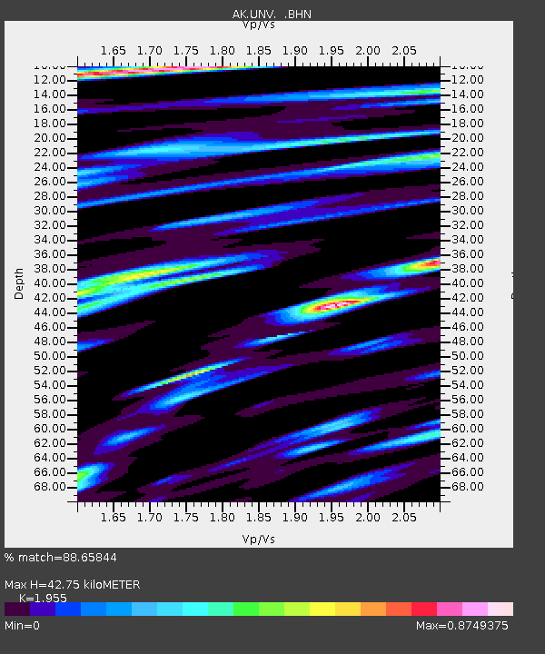
| Estimated Moho Depth: |
42.75 km |
| Estimated Crust Vp/Vs: |
1.96 |
| Assumed Crust Vp: |
3.943 km/s |
| Estimated Crust Vs: |
2.017 km/s |
| Estimated Crust Poisson's Ratio: |
0.32 |
|
| Radial Match: |
88.65844 % |
| Radial Bump: |
383 |
| Transverse Match: |
82.66606 % |
| Transverse Bump: |
400 |
| SOD ConfigId: |
626651 |
| Insert Time: |
2014-04-19 03:16:41.178 +0000 |
| GWidth: |
2.5 |
| Max Bumps: |
400 |
| Tol: |
0.001 |
|

Signal To Noise
| Channel | StoN | STA | LTA |
| AK:UNV: :BHZ:20131015T00:23:10.77998Z | 2.177469 | 1.5422789E-6 | 7.082897E-7 |
| AK:UNV: :BHN:20131015T00:23:10.77998Z | 1.3278309 | 6.343738E-7 | 4.7775194E-7 |
| AK:UNV: :BHE:20131015T00:23:10.77998Z | 0.87375164 | 4.5326172E-7 | 5.187535E-7 |
| Arrivals |
| Ps | 10 SECOND |
| PpPs | 32 SECOND |
| PsPs/PpSs | 42 SECOND |


