You are here: Home > Network List > AK - Alaska Regional Network Stations List
> Station WAT5 Susitna Watana 5, AK, USA > Earthquake Result Viewer
WAT5 Susitna Watana 5, AK, USA - Earthquake Result Viewer
| Earthquake location: |
Mindanao, Philippines |
| Earthquake latitude/longitude: |
9.9/124.1 |
| Earthquake time(UTC): |
2013/10/15 (288) 00:12:32 GMT |
| Earthquake Depth: |
19 km |
| Earthquake Magnitude: |
7.1 MWW, 7.1 MWC, 7.2 MI |
| Earthquake Catalog/Contributor: |
NEIC PDE/NEIC COMCAT |
|
| Network: |
AK Alaska Regional Network |
| Station: |
WAT5 Susitna Watana 5, AK, USA |
| Lat/Lon: |
63.06 N/148.23 W |
| Elevation: |
1691 m |
|
| Distance: |
80.2 deg |
| Az: |
27.503 deg |
| Baz: |
272.428 deg |
| Ray Param: |
0.0484194 |
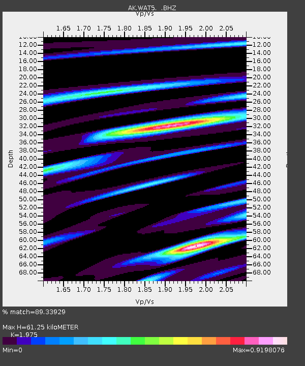
| Estimated Moho Depth: |
61.25 km |
| Estimated Crust Vp/Vs: |
1.98 |
| Assumed Crust Vp: |
6.566 km/s |
| Estimated Crust Vs: |
3.325 km/s |
| Estimated Crust Poisson's Ratio: |
0.33 |
|
| Radial Match: |
89.33929 % |
| Radial Bump: |
400 |
| Transverse Match: |
79.58299 % |
| Transverse Bump: |
400 |
| SOD ConfigId: |
626651 |
| Insert Time: |
2014-04-19 03:16:50.686 +0000 |
| GWidth: |
2.5 |
| Max Bumps: |
400 |
| Tol: |
0.001 |
|

Signal To Noise
| Channel | StoN | STA | LTA |
| AK:WAT5: :BHZ:20131015T00:24:09.787976Z | 1.7366132 | 6.590906E-7 | 3.795264E-7 |
| AK:WAT5: :BHN:20131015T00:24:09.787976Z | 1.1414258 | 1.6166155E-7 | 1.4163125E-7 |
| AK:WAT5: :BHE:20131015T00:24:09.787976Z | 2.3782332 | 3.8288024E-7 | 1.6099357E-7 |
| Arrivals |
| Ps | 9.3 SECOND |
| PpPs | 27 SECOND |
| PsPs/PpSs | 36 SECOND |


