You are here: Home > Network List > AU - Australian Seismological Centre Stations List
> Station MAW Mawson, Antarctica > Earthquake Result Viewer
MAW Mawson, Antarctica - Earthquake Result Viewer
| Earthquake location: |
Mindanao, Philippines |
| Earthquake latitude/longitude: |
9.9/124.1 |
| Earthquake time(UTC): |
2013/10/15 (288) 00:12:32 GMT |
| Earthquake Depth: |
19 km |
| Earthquake Magnitude: |
7.1 MWW, 7.1 MWC, 7.2 MI |
| Earthquake Catalog/Contributor: |
NEIC PDE/NEIC COMCAT |
|
| Network: |
AU Australian Seismological Centre |
| Station: |
MAW Mawson, Antarctica |
| Lat/Lon: |
67.60 S/62.87 E |
| Elevation: |
12 m |
|
| Distance: |
88.6 deg |
| Az: |
199.636 deg |
| Baz: |
59.781 deg |
| Ray Param: |
0.042440217 |
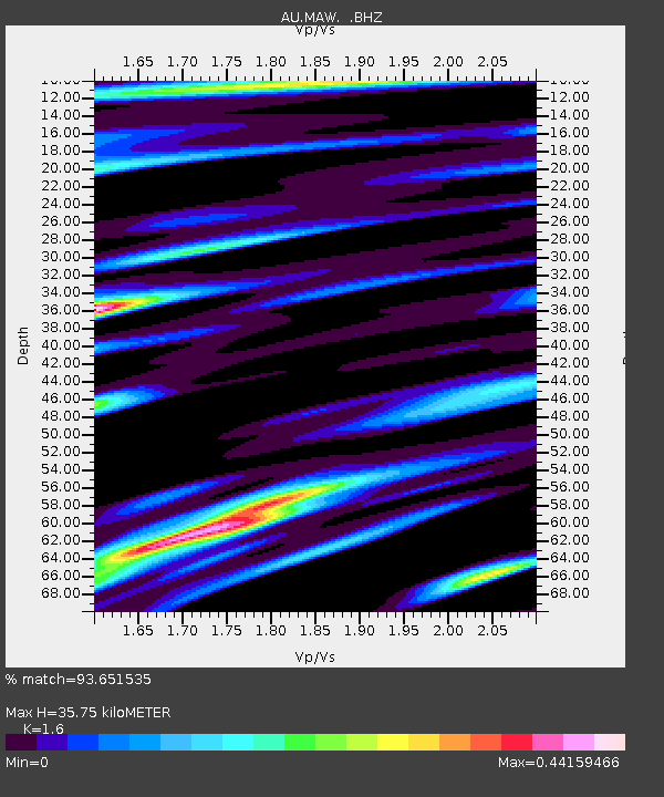
| Estimated Moho Depth: |
35.75 km |
| Estimated Crust Vp/Vs: |
1.60 |
| Assumed Crust Vp: |
6.508 km/s |
| Estimated Crust Vs: |
4.067 km/s |
| Estimated Crust Poisson's Ratio: |
0.18 |
|
| Radial Match: |
93.651535 % |
| Radial Bump: |
400 |
| Transverse Match: |
87.653114 % |
| Transverse Bump: |
400 |
| SOD ConfigId: |
626651 |
| Insert Time: |
2014-04-19 03:17:25.566 +0000 |
| GWidth: |
2.5 |
| Max Bumps: |
400 |
| Tol: |
0.001 |
|

Signal To Noise
| Channel | StoN | STA | LTA |
| AU:MAW: :BHZ:20131015T00:24:52.211987Z | 6.1915493 | 1.1882081E-7 | 1.9190804E-8 |
| AU:MAW: :BHN:20131015T00:24:52.211987Z | 1.2067007 | 3.1522045E-8 | 2.6122505E-8 |
| AU:MAW: :BHE:20131015T00:24:52.211987Z | 1.4253209 | 3.640843E-8 | 2.5544024E-8 |
| Arrivals |
| Ps | 3.4 SECOND |
| PpPs | 14 SECOND |
| PsPs/PpSs | 17 SECOND |


