You are here: Home > Network List > CB - China National Seismic Network Stations List
> Station GTA Gaotai,Gansu Province > Earthquake Result Viewer
GTA Gaotai,Gansu Province - Earthquake Result Viewer
| Earthquake location: |
Mindanao, Philippines |
| Earthquake latitude/longitude: |
9.9/124.1 |
| Earthquake time(UTC): |
2013/10/15 (288) 00:12:32 GMT |
| Earthquake Depth: |
19 km |
| Earthquake Magnitude: |
7.1 MWW, 7.1 MWC, 7.2 MI |
| Earthquake Catalog/Contributor: |
NEIC PDE/NEIC COMCAT |
|
| Network: |
CB China National Seismic Network |
| Station: |
GTA Gaotai,Gansu Province |
| Lat/Lon: |
39.40 N/99.82 E |
| Elevation: |
1345 m |
|
| Distance: |
36.5 deg |
| Az: |
327.607 deg |
| Baz: |
137.054 deg |
| Ray Param: |
0.07661146 |
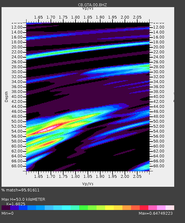
| Estimated Moho Depth: |
53.0 km |
| Estimated Crust Vp/Vs: |
1.68 |
| Assumed Crust Vp: |
6.491 km/s |
| Estimated Crust Vs: |
3.858 km/s |
| Estimated Crust Poisson's Ratio: |
0.23 |
|
| Radial Match: |
95.91611 % |
| Radial Bump: |
283 |
| Transverse Match: |
93.140144 % |
| Transverse Bump: |
400 |
| SOD ConfigId: |
626651 |
| Insert Time: |
2014-04-19 03:18:17.244 +0000 |
| GWidth: |
2.5 |
| Max Bumps: |
400 |
| Tol: |
0.001 |
|

Signal To Noise
| Channel | StoN | STA | LTA |
| CB:GTA:00:BHZ:20131015T00:19:05.509991Z | 7.4089103 | 4.290965E-7 | 5.7916278E-8 |
| CB:GTA:00:BHN:20131015T00:19:05.509991Z | 5.257767 | 2.2130338E-7 | 4.2090754E-8 |
| CB:GTA:00:BHE:20131015T00:19:05.509991Z | 4.2150984 | 2.0565068E-7 | 4.8789058E-8 |
| Arrivals |
| Ps | 6.0 SECOND |
| PpPs | 20 SECOND |
| PsPs/PpSs | 26 SECOND |


