You are here: Home > Network List > II - Global Seismograph Network (GSN - IRIS/IDA) Stations List
> Station NIL Nilore, Pakistan > Earthquake Result Viewer
NIL Nilore, Pakistan - Earthquake Result Viewer

| Earthquake location: |
Mindanao, Philippines |
| Earthquake latitude/longitude: |
9.9/124.1 |
| Earthquake time(UTC): |
2013/10/15 (288) 00:12:32 GMT |
| Earthquake Depth: |
19 km |
| Earthquake Magnitude: |
7.1 MWW, 7.1 MWC, 7.2 MI |
| Earthquake Catalog/Contributor: |
NEIC PDE/NEIC COMCAT |
|
| Network: |
II Global Seismograph Network (GSN - IRIS/IDA) |
| Station: |
NIL Nilore, Pakistan |
| Lat/Lon: |
33.65 N/73.27 E |
| Elevation: |
629 m |
|
| Distance: |
52.2 deg |
| Az: |
305.045 deg |
| Baz: |
104.734 deg |
| Ray Param: |
0.06689275 |
| Estimated Moho Depth: |
16.0 km |
| Estimated Crust Vp/Vs: |
1.71 |
| Assumed Crust Vp: |
6.242 km/s |
| Estimated Crust Vs: |
3.65 km/s |
| Estimated Crust Poisson's Ratio: |
0.24 |
|
| Radial Match: |
93.59922 % |
| Radial Bump: |
400 |
| Transverse Match: |
87.505066 % |
| Transverse Bump: |
400 |
| SOD ConfigId: |
626651 |
| Insert Time: |
2014-04-19 03:21:17.635 +0000 |
| GWidth: |
2.5 |
| Max Bumps: |
400 |
| Tol: |
0.001 |
|
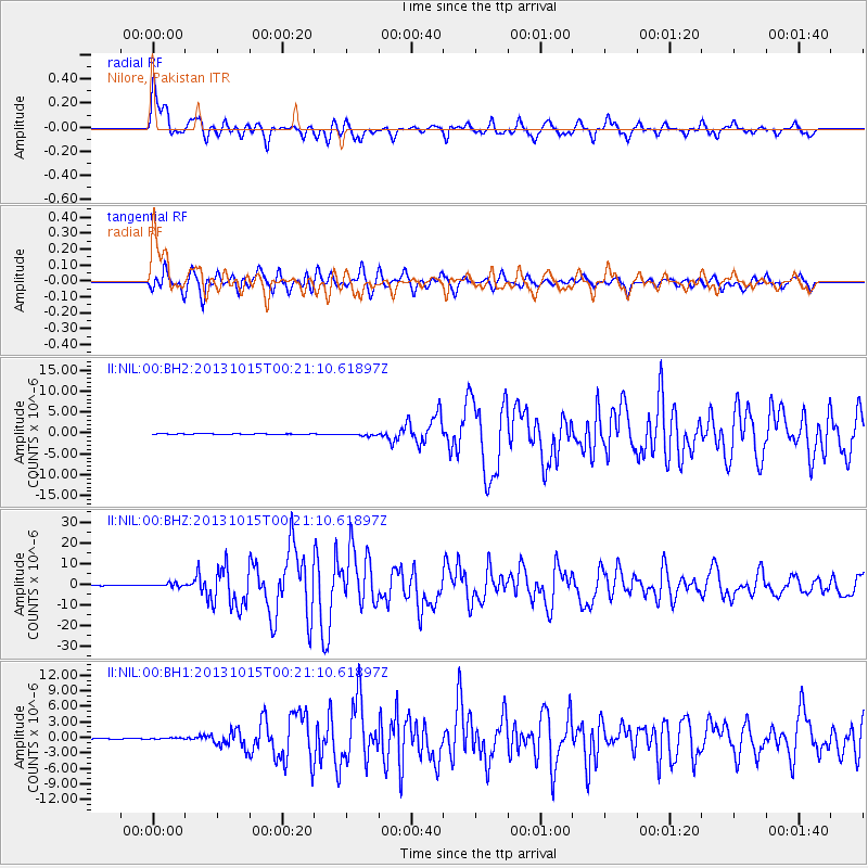
Signal To Noise
| Channel | StoN | STA | LTA |
| II:NIL:00:BHZ:20131015T00:21:10.61897Z | 7.9617863 | 9.1515204E-7 | 1.14943056E-7 |
| II:NIL:00:BH1:20131015T00:21:10.61897Z | 1.0515331 | 1.2501836E-7 | 1.18891506E-7 |
| II:NIL:00:BH2:20131015T00:21:10.61897Z | 5.6548676 | 3.374089E-7 | 5.966699E-8 |
| Arrivals |
| Ps | 1.9 SECOND |
| PpPs | 6.6 SECOND |
| PsPs/PpSs | 8.5 SECOND |


