You are here: Home > Network List > IU - Global Seismograph Network (GSN - IRIS/USGS) Stations List
> Station KMBO Kilima Mbogo, Kenya > Earthquake Result Viewer
KMBO Kilima Mbogo, Kenya - Earthquake Result Viewer
| Earthquake location: |
Mindanao, Philippines |
| Earthquake latitude/longitude: |
9.9/124.1 |
| Earthquake time(UTC): |
2013/10/15 (288) 00:12:32 GMT |
| Earthquake Depth: |
19 km |
| Earthquake Magnitude: |
7.1 MWW, 7.1 MWC, 7.2 MI |
| Earthquake Catalog/Contributor: |
NEIC PDE/NEIC COMCAT |
|
| Network: |
IU Global Seismograph Network (GSN - IRIS/USGS) |
| Station: |
KMBO Kilima Mbogo, Kenya |
| Lat/Lon: |
1.13 S/37.25 E |
| Elevation: |
1950 m |
|
| Distance: |
87.1 deg |
| Az: |
268.36 deg |
| Baz: |
80.113 deg |
| Ray Param: |
0.043551106 |
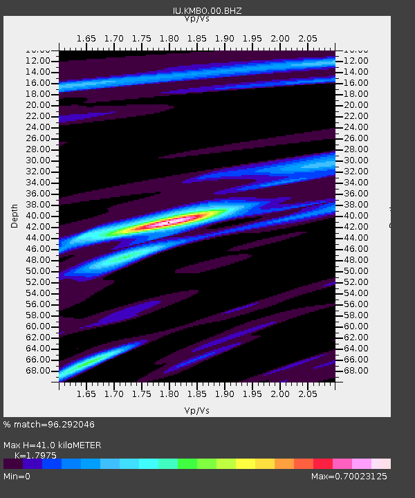
| Estimated Moho Depth: |
41.0 km |
| Estimated Crust Vp/Vs: |
1.80 |
| Assumed Crust Vp: |
6.601 km/s |
| Estimated Crust Vs: |
3.672 km/s |
| Estimated Crust Poisson's Ratio: |
0.28 |
|
| Radial Match: |
96.292046 % |
| Radial Bump: |
361 |
| Transverse Match: |
89.50747 % |
| Transverse Bump: |
400 |
| SOD ConfigId: |
626651 |
| Insert Time: |
2014-04-19 03:21:57.764 +0000 |
| GWidth: |
2.5 |
| Max Bumps: |
400 |
| Tol: |
0.001 |
|

Signal To Noise
| Channel | StoN | STA | LTA |
| IU:KMBO:00:BHZ:20131015T00:24:45.018994Z | 4.4780903 | 1.897637E-7 | 4.237603E-8 |
| IU:KMBO:00:BH1:20131015T00:24:45.018994Z | 0.94405174 | 3.5238052E-8 | 3.7326398E-8 |
| IU:KMBO:00:BH2:20131015T00:24:45.018994Z | 1.5926455 | 1.092224E-7 | 6.8579226E-8 |
| Arrivals |
| Ps | 5.1 SECOND |
| PpPs | 17 SECOND |
| PsPs/PpSs | 22 SECOND |


