You are here: Home > Network List > MN - MEDNET Project Stations List
> Station VTS Vitosha, Bulgary > Earthquake Result Viewer
VTS Vitosha, Bulgary - Earthquake Result Viewer
| Earthquake location: |
Mindanao, Philippines |
| Earthquake latitude/longitude: |
9.9/124.1 |
| Earthquake time(UTC): |
2013/10/15 (288) 00:12:32 GMT |
| Earthquake Depth: |
19 km |
| Earthquake Magnitude: |
7.1 MWW, 7.1 MWC, 7.2 MI |
| Earthquake Catalog/Contributor: |
NEIC PDE/NEIC COMCAT |
|
| Network: |
MN MEDNET Project |
| Station: |
VTS Vitosha, Bulgary |
| Lat/Lon: |
42.62 N/23.24 E |
| Elevation: |
1490 m |
|
| Distance: |
91.3 deg |
| Az: |
313.527 deg |
| Baz: |
75.441 deg |
| Ray Param: |
0.041612003 |
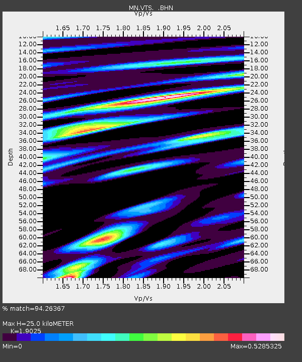
| Estimated Moho Depth: |
25.0 km |
| Estimated Crust Vp/Vs: |
1.90 |
| Assumed Crust Vp: |
6.291 km/s |
| Estimated Crust Vs: |
3.307 km/s |
| Estimated Crust Poisson's Ratio: |
0.31 |
|
| Radial Match: |
94.26367 % |
| Radial Bump: |
399 |
| Transverse Match: |
81.60883 % |
| Transverse Bump: |
400 |
| SOD ConfigId: |
626651 |
| Insert Time: |
2014-04-19 03:23:21.643 +0000 |
| GWidth: |
2.5 |
| Max Bumps: |
400 |
| Tol: |
0.001 |
|
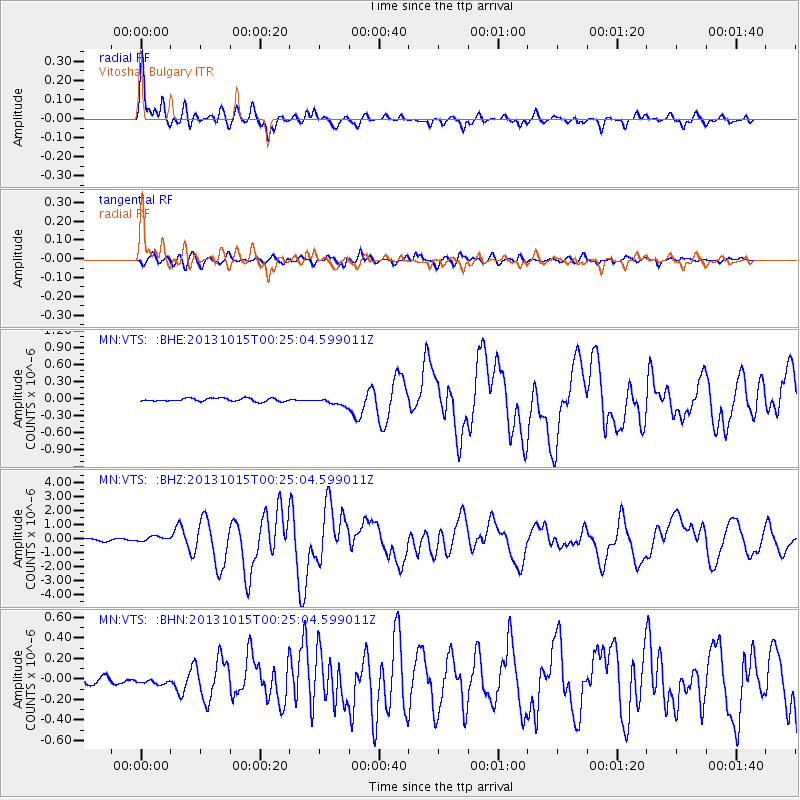
Signal To Noise
| Channel | StoN | STA | LTA |
| MN:VTS: :BHZ:20131015T00:25:04.599011Z | 3.087102 | 1.96537E-7 | 6.366392E-8 |
| MN:VTS: :BHN:20131015T00:25:04.599011Z | 0.63736224 | 3.6723726E-8 | 5.7618298E-8 |
| MN:VTS: :BHE:20131015T00:25:04.599011Z | 2.4588299 | 6.94031E-8 | 2.8226067E-8 |
| Arrivals |
| Ps | 3.7 SECOND |
| PpPs | 11 SECOND |
| PsPs/PpSs | 15 SECOND |


