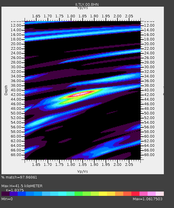
TLY Talaya, Russia - Earthquake Result Viewer

Earthquake location: Andreanof Islands, Aleutian Is.
Earthquake latitude/longitude: 51.3/-178.7
Earthquake time(UTC): 1993/05/15 (135) 21:52:25 GMT
Earthquake Depth: 33 km
Earthquake Magnitude: 6.2 MB, 6.5 MS, 6.3 UNKNOWN, 6.1 ML
Earthquake Catalog/Contributor: WHDF/NEIC
Network: II Global Seismograph Network (GSN - IRIS/IDA)
Station: TLY Talaya, Russia
Lat/Lon: 51.68 N/103.64 E
Elevation: 579 m
Distance: 46.2 deg
Az: 302.499 deg
Baz: 58.179 deg
Ray Param: 0.07075458
Estimated Moho Depth: 41.5 km
Estimated Crust Vp/Vs: 1.84
Assumed Crust Vp: 6.419 km/s
Estimated Crust Vs: 3.493 km/s
Estimated Crust Poisson's Ratio: 0.29
Radial Match: 97.96861 %
Radial Bump: 282
Transverse Match: 83.90025 %
Transverse Bump: 400
SOD ConfigId: 61242
Insert Time: 2010-03-01 17:22:42.673 +0000
GWidth: 2.5
Max Bumps: 400
Tol: 0.001

Signal To Noise

ChannelStoNSTALTA
II:TLY:00:BHN:19930515T22:00:16.247992Z19.8617697.4374793E-73.744621E-8
II:TLY:00:BHE:19930515T22:00:16.247992Z17.9044328.425675E-74.705916E-8
II:TLY:00:BHZ:19930515T22:00:16.247992Z27.2397791.8377721E-66.746648E-8
Arrivals
Ps5.8 SECOND
PpPs17 SECOND
PsPs/PpSs23 SECOND