You are here: Home > Network List > CI - Caltech Regional Seismic Network Stations List
> Station TIN Tinemaha, Big Pine, CA, USA > Earthquake Result Viewer
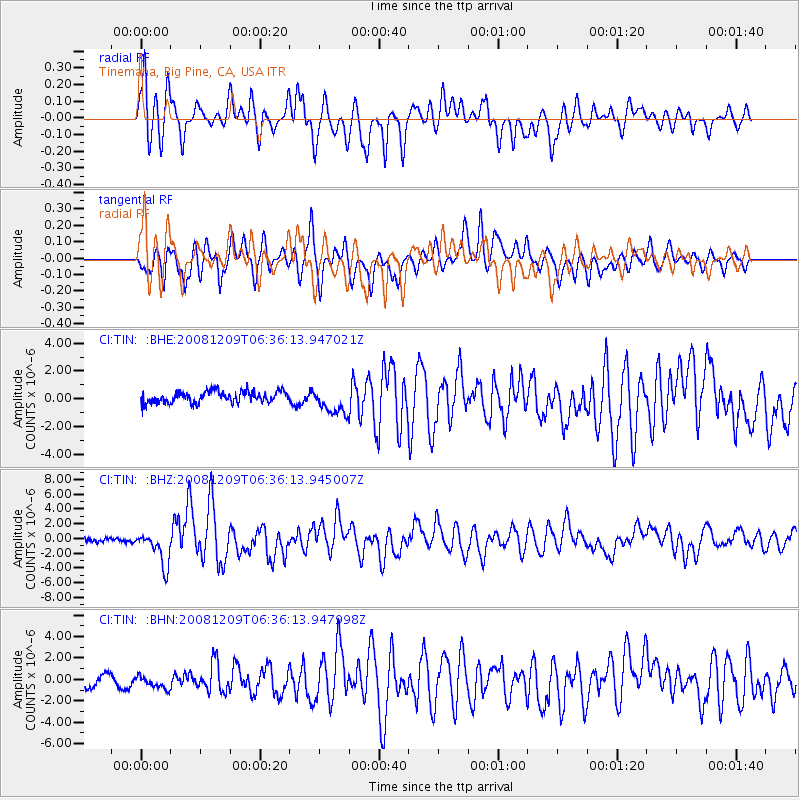
TIN Tinemaha, Big Pine, CA, USA - Earthquake Result Viewer
*The percent match for this event was below the threshold and hence no stack was calculated.
| Earthquake location: |
Kermadec Islands Region |
| Earthquake latitude/longitude: |
-31.2/-176.9 |
| Earthquake time(UTC): |
2008/12/09 (344) 06:23:59 GMT |
| Earthquake Depth: |
18 km |
| Earthquake Magnitude: |
6.2 MB, 6.7 MS, 6.8 MW, 6.7 MW |
| Earthquake Catalog/Contributor: |
WHDF/NEIC |
|
| Network: |
CI Caltech Regional Seismic Network |
| Station: |
TIN Tinemaha, Big Pine, CA, USA |
| Lat/Lon: |
37.05 N/118.23 W |
| Elevation: |
1197 m |
|
| Distance: |
87.3 deg |
| Az: |
43.178 deg |
| Baz: |
227.112 deg |
| Ray Param: |
$rayparam |
*The percent match for this event was below the threshold and hence was not used in the summary stack. |
|
| Radial Match: |
79.52747 % |
| Radial Bump: |
400 |
| Transverse Match: |
73.141785 % |
| Transverse Bump: |
400 |
| SOD ConfigId: |
2658 |
| Insert Time: |
2010-02-25 20:52:54.249 +0000 |
| GWidth: |
2.5 |
| Max Bumps: |
400 |
| Tol: |
0.001 |
|
Signal To Noise
| Channel | StoN | STA | LTA |
| CI:TIN: :BHZ:20081209T06:36:13.945007Z | 8.892398 | 2.285811E-6 | 2.5705225E-7 |
| CI:TIN: :BHN:20081209T06:36:13.947998Z | 0.97503763 | 5.9631594E-7 | 6.1158255E-7 |
| CI:TIN: :BHE:20081209T06:36:13.947021Z | 2.2969234 | 9.4079223E-7 | 4.09588E-7 |
| Arrivals |
| Ps | |
| PpPs | |
| PsPs/PpSs | |


