You are here: Home > Network List > AV - Alaska Volcano Observatory Stations List
> Station SPCR Ckakachatna River, Mount Spurr, Alaska > Earthquake Result Viewer
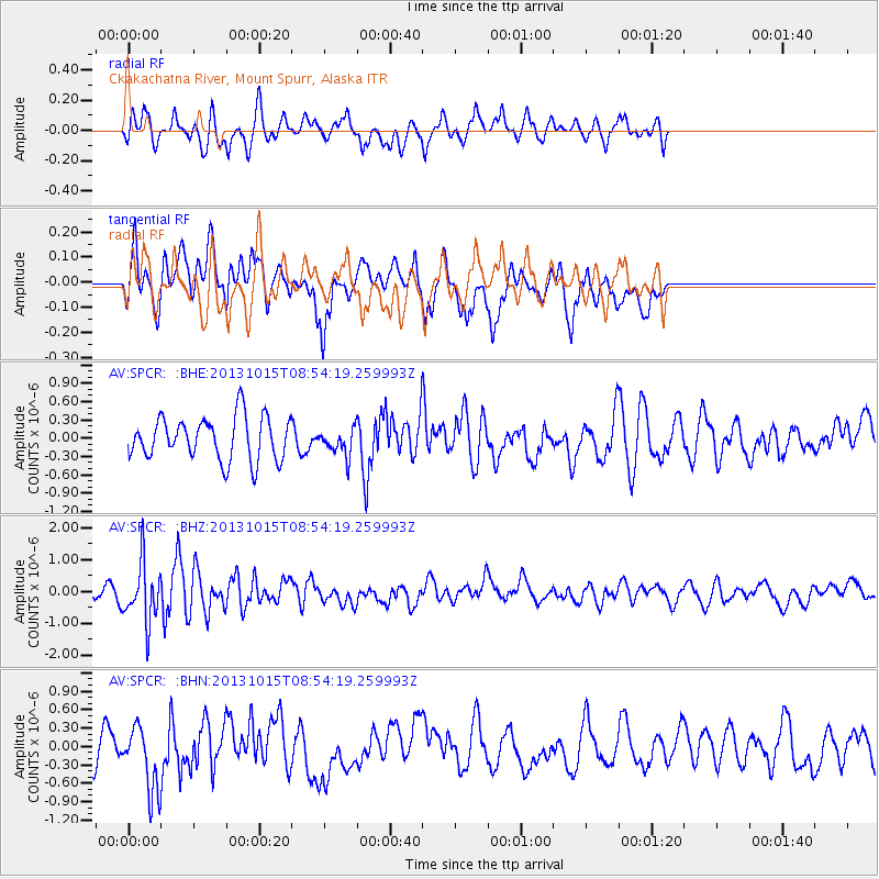
SPCR Ckakachatna River, Mount Spurr, Alaska - Earthquake Result Viewer
*The percent match for this event was below the threshold and hence no stack was calculated.
| Earthquake location: |
Negros, Philippines |
| Earthquake latitude/longitude: |
9.8/123.7 |
| Earthquake time(UTC): |
2013/10/15 (288) 08:42:49 GMT |
| Earthquake Depth: |
16 km |
| Earthquake Magnitude: |
5.7 MWW, 5.5 MWB, 5.7 MWW, 5.7 MWC |
| Earthquake Catalog/Contributor: |
NEIC PDE/NEIC COMCAT |
|
| Network: |
AV Alaska Volcano Observatory |
| Station: |
SPCR Ckakachatna River, Mount Spurr, Alaska |
| Lat/Lon: |
61.20 N/152.21 W |
| Elevation: |
984 m |
|
| Distance: |
78.6 deg |
| Az: |
29.425 deg |
| Baz: |
269.604 deg |
| Ray Param: |
$rayparam |
*The percent match for this event was below the threshold and hence was not used in the summary stack. |
|
| Radial Match: |
56.996174 % |
| Radial Bump: |
393 |
| Transverse Match: |
50.89098 % |
| Transverse Bump: |
400 |
| SOD ConfigId: |
626651 |
| Insert Time: |
2014-04-19 03:40:28.929 +0000 |
| GWidth: |
2.5 |
| Max Bumps: |
400 |
| Tol: |
0.001 |
|
Signal To Noise
| Channel | StoN | STA | LTA |
| AV:SPCR: :BHZ:20131015T08:54:19.259993Z | 3.6969216 | 9.231728E-7 | 2.4971393E-7 |
| AV:SPCR: :BHN:20131015T08:54:19.259993Z | 1.9088509 | 5.202618E-7 | 2.7255234E-7 |
| AV:SPCR: :BHE:20131015T08:54:19.259993Z | 0.5992734 | 2.103926E-7 | 3.510795E-7 |
| Arrivals |
| Ps | |
| PpPs | |
| PsPs/PpSs | |


