You are here: Home > Network List > IU - Global Seismograph Network (GSN - IRIS/USGS) Stations List
> Station CTAO Charters Towers, Australia > Earthquake Result Viewer
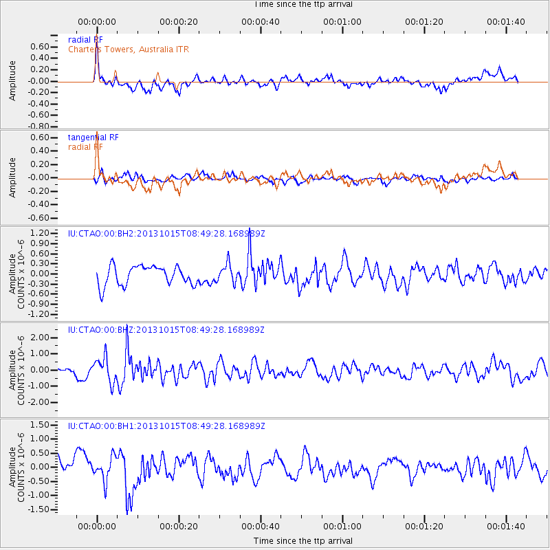
CTAO Charters Towers, Australia - Earthquake Result Viewer
*The percent match for this event was below the threshold and hence no stack was calculated.
| Earthquake location: |
Negros, Philippines |
| Earthquake latitude/longitude: |
9.8/123.7 |
| Earthquake time(UTC): |
2013/10/15 (288) 08:42:49 GMT |
| Earthquake Depth: |
16 km |
| Earthquake Magnitude: |
5.7 MWW, 5.5 MWB, 5.7 MWW, 5.7 MWC |
| Earthquake Catalog/Contributor: |
NEIC PDE/NEIC COMCAT |
|
| Network: |
IU Global Seismograph Network (GSN - IRIS/USGS) |
| Station: |
CTAO Charters Towers, Australia |
| Lat/Lon: |
20.09 S/146.25 E |
| Elevation: |
357 m |
|
| Distance: |
37.1 deg |
| Az: |
143.26 deg |
| Baz: |
321.15 deg |
| Ray Param: |
$rayparam |
*The percent match for this event was below the threshold and hence was not used in the summary stack. |
|
| Radial Match: |
65.23086 % |
| Radial Bump: |
400 |
| Transverse Match: |
42.90218 % |
| Transverse Bump: |
315 |
| SOD ConfigId: |
626651 |
| Insert Time: |
2014-04-19 03:44:02.790 +0000 |
| GWidth: |
2.5 |
| Max Bumps: |
400 |
| Tol: |
0.001 |
|
Signal To Noise
| Channel | StoN | STA | LTA |
| IU:CTAO:00:BHZ:20131015T08:49:28.168989Z | 4.043513 | 7.875032E-7 | 1.9475719E-7 |
| IU:CTAO:00:BH1:20131015T08:49:28.168989Z | 1.3669287 | 4.2375234E-7 | 3.1000323E-7 |
| IU:CTAO:00:BH2:20131015T08:49:28.168989Z | 0.9621425 | 2.7223678E-7 | 2.829485E-7 |
| Arrivals |
| Ps | |
| PpPs | |
| PsPs/PpSs | |


