You are here: Home > Network List > UW - Pacific Northwest Regional Seismic Network Stations List
> Station LEBA Lebam, WA, USA > Earthquake Result Viewer
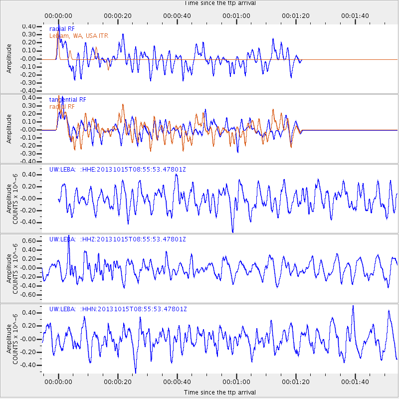
LEBA Lebam, WA, USA - Earthquake Result Viewer
*The percent match for this event was below the threshold and hence no stack was calculated.
| Earthquake location: |
Negros, Philippines |
| Earthquake latitude/longitude: |
9.8/123.7 |
| Earthquake time(UTC): |
2013/10/15 (288) 08:42:49 GMT |
| Earthquake Depth: |
16 km |
| Earthquake Magnitude: |
5.7 MWW, 5.5 MWB, 5.7 MWW, 5.7 MWC |
| Earthquake Catalog/Contributor: |
NEIC PDE/NEIC COMCAT |
|
| Network: |
UW Pacific Northwest Regional Seismic Network |
| Station: |
LEBA Lebam, WA, USA |
| Lat/Lon: |
46.55 N/123.56 W |
| Elevation: |
73 m |
|
| Distance: |
98.1 deg |
| Az: |
40.01 deg |
| Baz: |
293.351 deg |
| Ray Param: |
$rayparam |
*The percent match for this event was below the threshold and hence was not used in the summary stack. |
|
| Radial Match: |
58.646904 % |
| Radial Bump: |
400 |
| Transverse Match: |
63.293587 % |
| Transverse Bump: |
400 |
| SOD ConfigId: |
626651 |
| Insert Time: |
2014-04-19 03:48:02.631 +0000 |
| GWidth: |
2.5 |
| Max Bumps: |
400 |
| Tol: |
0.001 |
|
Signal To Noise
| Channel | StoN | STA | LTA |
| UW:LEBA: :HHZ:20131015T08:55:53.47801Z | 3.1410017 | 2.4291776E-7 | 7.733767E-8 |
| UW:LEBA: :HHN:20131015T08:55:53.47801Z | 0.6410735 | 1.0573619E-7 | 1.6493614E-7 |
| UW:LEBA: :HHE:20131015T08:55:53.47801Z | 0.77137995 | 1.2001605E-7 | 1.5558618E-7 |
| Arrivals |
| Ps | |
| PpPs | |
| PsPs/PpSs | |


