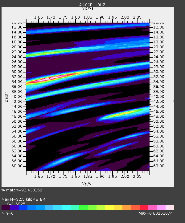
CCB Clear Creek Butte - Earthquake Result Viewer

Earthquake location: Solomon Islands
Earthquake latitude/longitude: -6.4/154.9
Earthquake time(UTC): 2013/10/16 (289) 10:30:58 GMT
Earthquake Depth: 35 km
Earthquake Magnitude: 6.8 MWW, 6.7 MWB, 6.8 MWW, 6.8 MWC, 7.1 MI
Earthquake Catalog/Contributor: NEIC PDE/NEIC COMCAT
Network: AK Alaska Regional Network
Station: CCB Clear Creek Butte
Lat/Lon: 64.65 N/147.80 W
Elevation: 248 m
Distance: 82.5 deg
Az: 21.427 deg
Baz: 237.478 deg
Ray Param: 0.046804037
Estimated Moho Depth: 32.5 km
Estimated Crust Vp/Vs: 1.69
Assumed Crust Vp: 6.566 km/s
Estimated Crust Vs: 3.88 km/s
Estimated Crust Poisson's Ratio: 0.23
Radial Match: 92.438156 %
Radial Bump: 312
Transverse Match: 85.291534 %
Transverse Bump: 400
SOD ConfigId: 626651
Insert Time: 2014-04-19 03:49:04.555 +0000
GWidth: 2.5
Max Bumps: 400
Tol: 0.001

Signal To Noise

ChannelStoNSTALTA
AK:CCB: :BHZ:20131016T10:42:46.388013Z41.8501056.5207773E-61.5581269E-7
AK:CCB: :BHN:20131016T10:42:46.388013Z8.6046111.146997E-61.3330026E-7
AK:CCB: :BHE:20131016T10:42:46.388013Z13.3750651.7442778E-61.3041266E-7
Arrivals
Ps3.5 SECOND
PpPs13 SECOND
PsPs/PpSs16 SECOND