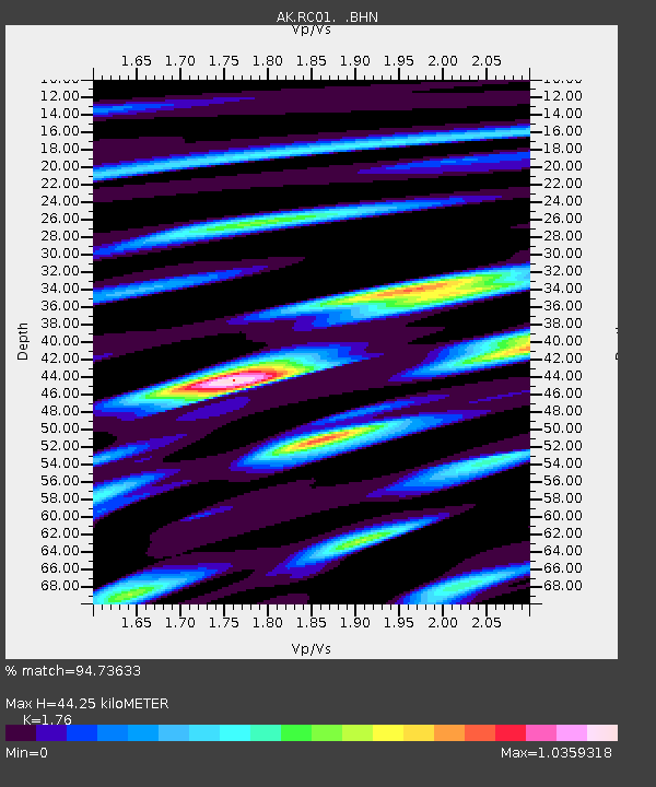
RC01 Rabbit Creek - Earthquake Result Viewer

Earthquake location: Solomon Islands
Earthquake latitude/longitude: -6.4/154.9
Earthquake time(UTC): 2013/10/16 (289) 10:30:58 GMT
Earthquake Depth: 35 km
Earthquake Magnitude: 6.8 MWW, 6.7 MWB, 6.8 MWW, 6.8 MWC, 7.1 MI
Earthquake Catalog/Contributor: NEIC PDE/NEIC COMCAT
Network: AK Alaska Regional Network
Station: RC01 Rabbit Creek
Lat/Lon: 61.09 N/149.74 W
Elevation: 383 m
Distance: 79.8 deg
Az: 23.959 deg
Baz: 236.148 deg
Ray Param: 0.04866871
Estimated Moho Depth: 44.25 km
Estimated Crust Vp/Vs: 1.76
Assumed Crust Vp: 6.566 km/s
Estimated Crust Vs: 3.731 km/s
Estimated Crust Poisson's Ratio: 0.26
Radial Match: 94.73633 %
Radial Bump: 400
Transverse Match: 78.44115 %
Transverse Bump: 400
SOD ConfigId: 626651
Insert Time: 2014-04-19 03:51:00.496 +0000
GWidth: 2.5
Max Bumps: 400
Tol: 0.001

Signal To Noise

ChannelStoNSTALTA
AK:RC01: :BHZ:20131016T10:42:32.099988Z26.7465727.778684E-62.908292E-7
AK:RC01: :BHN:20131016T10:42:32.099988Z3.55673051.3782543E-63.8750596E-7
AK:RC01: :BHE:20131016T10:42:32.099988Z12.7937133.1286172E-62.4454334E-7
Arrivals
Ps5.3 SECOND
PpPs18 SECOND
PsPs/PpSs23 SECOND