You are here: Home > Network List > CI - Caltech Regional Seismic Network Stations List
> Station TIN Tinemaha, California, USA > Earthquake Result Viewer
TIN Tinemaha, California, USA - Earthquake Result Viewer
*The percent match for this event was below the threshold and hence no stack was calculated.
| Earthquake location: |
Vanuatu Islands |
| Earthquake latitude/longitude: |
-13.6/166.8 |
| Earthquake time(UTC): |
1998/09/21 (264) 12:09:39 GMT |
| Earthquake Depth: |
33 km |
| Earthquake Magnitude: |
6.0 MB, 6.3 MS, 6.4 UNKNOWN, 6.3 MW |
| Earthquake Catalog/Contributor: |
WHDF/NEIC |
|
| Network: |
CI Caltech Regional Seismic Network |
| Station: |
TIN Tinemaha, California, USA |
| Lat/Lon: |
37.05 N/118.23 W |
| Elevation: |
1164 m |
|
| Distance: |
86.5 deg |
| Az: |
50.728 deg |
| Baz: |
250.219 deg |
| Ray Param: |
$rayparam |
*The percent match for this event was below the threshold and hence was not used in the summary stack. |
|
| Radial Match: |
73.60886 % |
| Radial Bump: |
400 |
| Transverse Match: |
61.2007 % |
| Transverse Bump: |
400 |
| SOD ConfigId: |
4480 |
| Insert Time: |
2010-02-25 20:52:54.662 +0000 |
| GWidth: |
2.5 |
| Max Bumps: |
400 |
| Tol: |
0.001 |
|
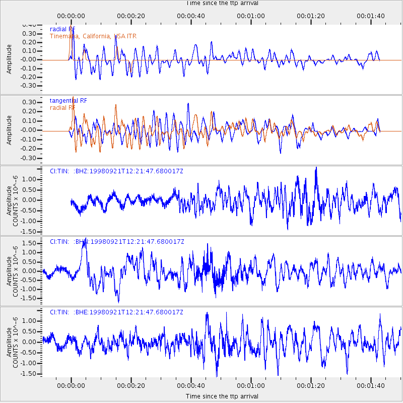
Signal To Noise
| Channel | StoN | STA | LTA |
| CI:TIN: :BHN:19980921T12:21:47.680017Z | 4.8300595 | 7.6263154E-7 | 1.5789279E-7 |
| CI:TIN: :BHE:19980921T12:21:47.680017Z | 1.108543 | 2.7494895E-7 | 2.4802733E-7 |
| CI:TIN: :BHZ:19980921T12:21:47.680017Z | 1.0388669 | 2.448493E-7 | 2.3568882E-7 |
| Arrivals |
| Ps | |
| PpPs | |
| PsPs/PpSs | |


